IMAGES TAKEN NEAR TO
Park Lane, SANDBACH, CW11 1EW
Introduction
This page details the photographs taken nearby to Park Lane, CW11 1EW by members of the Geograph project.
The Geograph project started in 2005 with the aim of publishing, organising and preserving representative images for every square kilometre of Great Britain, Ireland and the Isle of Man.

There are currently over 7.5m images from over14,400 individuals and you can help contribute to the project by visiting https://www.geograph.org.uk
Image Map
Images are licensed for reuse under creativecommons.org/licenses/by-sa/2.0
Notes
- Clicking on the map will re-center to the selected point.
- The higher the marker number, the further away the image location is from the centre of the postcode.
Image Listing (6 Images Found)
Images are licensed for reuse under creativecommons.org/licenses/by-sa/2.0
Image
Details
Distance
1
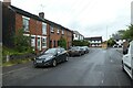
Park Lane
Looking towards the junction with Crewe Road.
Image: © DS Pugh
Taken: 5 Aug 2023
0.13 miles
2
Crewe Road near Park Lane
Looking along Crewe Road in Sandbach near the junction with Park Lane.
Image: © DS Pugh
Taken: 5 Aug 2023
0.14 miles
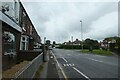
3
Bus stop on Crewe Road
The bus stop is listed as Sandbach Crewe Road / First Avenue.
Image: © DS Pugh
Taken: 5 Aug 2023
0.17 miles
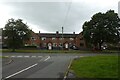
4
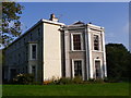
Abbeyfields, off Park Lane
A grade II Listed building, ca 1800. Situated on land once owned by Dieulacres Abbey, Staffordshire (Cistercian). Now converted into flats.
Image: © Chris Martyn
Taken: 9 Oct 2010
0.24 miles
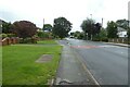
5
Third Avenue
Looking across Third Avenue from the end of Price Avenue.
Image: © DS Pugh
Taken: 5 Aug 2023
0.24 miles
6
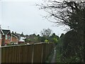
Footpath from Coronation Crescent to Mill Hill Lane
Old maps show that the footpath predates the housing estate.
Image: © Stephen Craven
Taken: 28 Dec 2021
0.25 miles