IMAGES TAKEN NEAR TO
Congleton Road, SANDBACH, CW11 1DN
Introduction
This page details the photographs taken nearby to Congleton Road, CW11 1DN by members of the Geograph project.
The Geograph project started in 2005 with the aim of publishing, organising and preserving representative images for every square kilometre of Great Britain, Ireland and the Isle of Man.

There are currently over 7.5m images from over14,400 individuals and you can help contribute to the project by visiting https://www.geograph.org.uk
Image Map
Images are licensed for reuse under creativecommons.org/licenses/by-sa/2.0
Notes
- Clicking on the map will re-center to the selected point.
- The higher the marker number, the further away the image location is from the centre of the postcode.
Image Listing (82 Images Found)
Images are licensed for reuse under creativecommons.org/licenses/by-sa/2.0
Image
Details
Distance
1
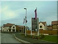
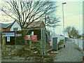
Bramley Wood: welcome sign
Approaching the show homes.
Image: © Stephen Craven
Taken: 28 Dec 2015
0.01 miles
2
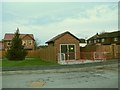
Bramley Wood: substation
A new substation to power the new development, with a Christmas tree alongside.
Image: © Stephen Craven
Taken: 28 Dec 2015
0.01 miles
3
Bramley Wood: entrance road
One large house was demolished to make an opening on the north of Congleton Road as a way in for construction traffic and eventually residents.
Image: © Stephen Craven
Taken: 29 Dec 2015
0.02 miles

5
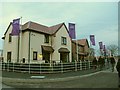
Bramley Wood: show homes
A pair of detached houses for show. This is not an "affordable" development.
Image: © Stephen Craven
Taken: 28 Dec 2015
0.03 miles
6
Bramley Wood: footpath closed
The public footpath from Congleton Road to Pillar Box Lane was closed during the construction period.
Image: © Stephen Craven
Taken: 28 Dec 2015
0.04 miles
7

Cabinets on Congleton Road
Alongside the main road, adjacent to the access road to the new Bramley Wood development. The road name sign includes all the names of roads on the estate:
Claymore Road, Elgan Crescent, Owen Close, Pasture Close, Fallows Close, Pipers Hollow, Long Beam Road, Mellors Field Close, Alder Croft Close and Sutton Place.
Image: © Stephen Craven
Taken: 30 Mar 2024
0.04 miles
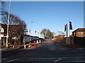
8
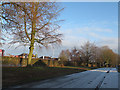
Icy service road
The service road parallel to the main Congleton Road, ungritted after a hard December frost.
Image: © Stephen Craven
Taken: 30 Dec 2016
0.04 miles
9

Elgan Crescent
The number of houses with double garages on this estate, and the lack of cycle lanes, cycle parking or bus stops anywhere, gives an indication of the developer's (and planning authority's) transport priorities.
Image: © Stephen Craven
Taken: 30 Mar 2024
0.04 miles
10
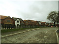
Bramley Wood estate - spine road
The houses on the left of the spine road into the estate were already completed, and at least some of them occupied, by March 2017.
Image: © Stephen Craven
Taken: 19 Mar 2017
0.05 miles