IMAGES TAKEN NEAR TO
Byley, MIDDLEWICH, CW10 9NR
Introduction
This page details the photographs taken nearby to CW10 9NR by members of the Geograph project.
The Geograph project started in 2005 with the aim of publishing, organising and preserving representative images for every square kilometre of Great Britain, Ireland and the Isle of Man.

There are currently over 7.5m images from over14,400 individuals and you can help contribute to the project by visiting https://www.geograph.org.uk
Image Map
Images are licensed for reuse under creativecommons.org/licenses/by-sa/2.0
Notes
- Clicking on the map will re-center to the selected point.
- The higher the marker number, the further away the image location is from the centre of the postcode.
Image Listing (4 Images Found)
Images are licensed for reuse under creativecommons.org/licenses/by-sa/2.0
Image
Details
Distance
1
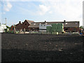
Drakelow Hall Farm, Byley
The view is from the byway running to the north of the farm.
Image: © Stephen Craven
Taken: 27 Jun 2010
0.02 miles
2
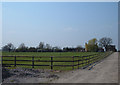
Drakelow Hall Farm, Byley
Situated about a mile northwest of Byley at the end of Drakelow Lane.
Image: © michael ely
Taken: 31 Mar 2007
0.03 miles
3
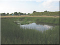
Marshy pond near Byley
The reeds around this pond hint at the conditions underfoot. That, and clumps of the nettles on the line of the byway that I was trying to follow (at this point effectively only a footpath rather than a track) caused me to turn back here.
Image: © Stephen Craven
Taken: 27 Jun 2010
0.14 miles
4
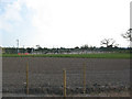
Plant for Holford gas project
One of several surface installations in the area serving this large utility project.
Image: © Stephen Craven
Taken: 27 Jun 2010
0.25 miles