IMAGES TAKEN NEAR TO
Kings Lane, MIDDLEWICH, CW10 9NA
Introduction
This page details the photographs taken nearby to Kings Lane, CW10 9NA by members of the Geograph project.
The Geograph project started in 2005 with the aim of publishing, organising and preserving representative images for every square kilometre of Great Britain, Ireland and the Isle of Man.

There are currently over 7.5m images from over14,400 individuals and you can help contribute to the project by visiting https://www.geograph.org.uk
Image Map
Images are licensed for reuse under creativecommons.org/licenses/by-sa/2.0
Notes
- Clicking on the map will re-center to the selected point.
- The higher the marker number, the further away the image location is from the centre of the postcode.
Image Listing (13 Images Found)
Images are licensed for reuse under creativecommons.org/licenses/by-sa/2.0
Image
Details
Distance
2
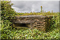
WWII Cheshire, RAF Cranage, near Middlewich - pillbox (1)
-
Pillbox (variant): DoB ID: S0000216
This large type 24 (variant) pillbox in the northeast corner of the former airfield, lies in a field on the south side of King's Lane. It has large stepped embrasures that enabled a 360 degree covering fire.
RAF Cranage was built just before the outbreak of the Second World War for use as an aircraft storage facility, but became a Relief Landing Ground (RLG) for No.5 Flying Training School by August 1940. In November Cranage became the No. 2 School of Air Navigation using Avro Anson aircraft, and renamed the Central Navigation School in 1942, remaining at Cranage until 1944. From May 1941 Avro Manchester bombers were stored at Cranage, and Wellington bombers also operated from here where they were assembled at an adjacent Vickers-Armstrong shadow factory, and test flown from Cranage prior to delivery to their units.
A fighter squadron was formed at Cranage during the latter half of 1940 No. 96 (Night Fighter) Squadron flying MkI Hurricanes in the defence of Liverpool. They moved from Cranage to RAF Wrexham in October 1941. The USAAF 14th Liaison Squadron arrived between May and June 1944 with Stinson L-5 Sentinal aircraft as part of the preparations for the D-Day landings. Flying and other activities at Cranage from mid June 1944 to the end of the war then gradually reduced, and then ceased altogether. After a period of use as a storage unit for the RAF until 1954, it reverted to the USAF who based a number of non-flying units here until they handed it back to the RAF in 1957. RAF Cranage was closed shortly after.
Image
Image: © Mike Searle
Taken: 3 Aug 2017
0.06 miles
3
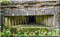
WWII Cheshire, RAF Cranage, near Middlewich - pillbox (2)
-
Pillbox (variant): DoB ID: S0000216
The embrasure has been fitted with a frame for a Turnbull machine gun mount.
Image
Image: © Mike Searle
Taken: 3 Aug 2017
0.06 miles
4

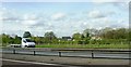
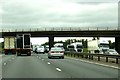
Cranage : M6 Motorway
The M6 Motorway between Junction 18 and Junction 19.
Image: © Lewis Clarke
Taken: 23 Sep 2019
0.13 miles
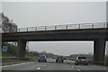
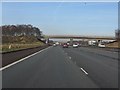
6
King's Lane crosses the M6
Heading north on the M6.
Image: © Steve Daniels
Taken: 17 Jun 2015
0.17 miles

9

South End of Shakerley Mere
Near to cross roads of B5082 & B5081 .
Image: © Ian Warburton
Taken: 25 Nov 2005
0.19 miles
10
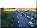
M6 from King's Lane, looking north
Always busy especially on Friday evening!!
(Bridge in distance carries the B5081)
Image: © Ian Warburton
Taken: 25 Nov 2005
0.19 miles