IMAGES TAKEN NEAR TO
Byley Lane, MIDDLEWICH, CW10 9LP
Introduction
This page details the photographs taken nearby to Byley Lane, CW10 9LP by members of the Geograph project.
The Geograph project started in 2005 with the aim of publishing, organising and preserving representative images for every square kilometre of Great Britain, Ireland and the Isle of Man.

There are currently over 7.5m images from over14,400 individuals and you can help contribute to the project by visiting https://www.geograph.org.uk
Image Map
Images are licensed for reuse under creativecommons.org/licenses/by-sa/2.0
Notes
- Clicking on the map will re-center to the selected point.
- The higher the marker number, the further away the image location is from the centre of the postcode.
Image Listing (6 Images Found)
Images are licensed for reuse under creativecommons.org/licenses/by-sa/2.0
Image
Details
Distance
1
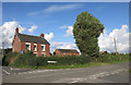
House on Middlewich Road
Looking OK in this 2007 picture Image this house is now looking a bit more dishevelled.
Image: © Des Blenkinsopp
Taken: 13 Aug 2014
0.22 miles
2
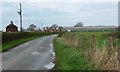
Buildings at Pump House Farm
Looking north along Byley Lane.
Image: © Christine Johnstone
Taken: 30 Mar 2017
0.23 miles
3
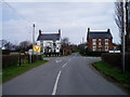
Crossroads between Goostrey and Middlewich
A simple crossroads on the minor road north of Pump House Farm between Goostrey and Middlewich in Cheshire
Image: © R Greenhalgh
Taken: 24 Mar 2007
0.24 miles
4
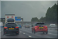
Cranage : M6 Motorway
The M6 between Junction 19 and Junction 18.
Image: © Lewis Clarke
Taken: 27 Sep 2019
0.24 miles
5

Cheshire West and Chester : The M6 Motorway
Heading northbound on the M6 Motorway.
Image: © Lewis Clarke
Taken: 21 Apr 2016
0.24 miles
6
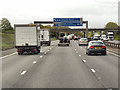
Sign Gantry and Byley Lane Bridge, Southbound M6 near Cranage
Image: © David Dixon
Taken: 13 May 2013
0.25 miles