IMAGES TAKEN NEAR TO
King Street, MIDDLEWICH, CW10 9LD
Introduction
This page details the photographs taken nearby to King Street, CW10 9LD by members of the Geograph project.
The Geograph project started in 2005 with the aim of publishing, organising and preserving representative images for every square kilometre of Great Britain, Ireland and the Isle of Man.

There are currently over 7.5m images from over14,400 individuals and you can help contribute to the project by visiting https://www.geograph.org.uk
Image Map
Images are licensed for reuse under creativecommons.org/licenses/by-sa/2.0
Notes
- Clicking on the map will re-center to the selected point.
- The higher the marker number, the further away the image location is from the centre of the postcode.
Image Listing (15 Images Found)
Images are licensed for reuse under creativecommons.org/licenses/by-sa/2.0
Image
Details
Distance
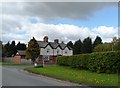
2
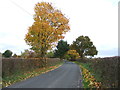
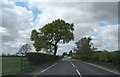
Autumn colours, Yatehouse Lane
Looking north east.
Image: © JThomas
Taken: 5 Nov 2016
0.07 miles
4
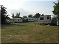
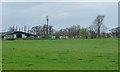
Caravan site at Yatehouse Farm
For details see https://www.ukcampsite.co.uk/sites/details.asp?revid=9145
Image: © Stephen Craven
Taken: 27 Jun 2010
0.12 miles
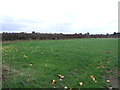
5
Caravans and a mast at Yatehouse Farm
On the north side of the farm buildings.
Image: © Christine Johnstone
Taken: 30 Mar 2017
0.19 miles
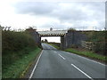
8
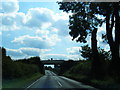
Four Point Two
Railway bridge over Croxton Lane (A530), near Middlewich.
Image: © J Scott
Taken: 25 Nov 2010
0.20 miles
10
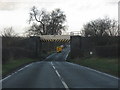
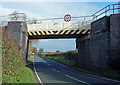
Railway overbridge, Croxton Lane
The railway line links Northwich and Sandbach and forms an occasional diversionary route for the main line between Manchester and Crewe.
Image: © Peter Whatley
Taken: 7 Dec 2011
0.21 miles