IMAGES TAKEN NEAR TO
Birch Lane, MIDDLEWICH, CW10 9JR
Introduction
This page details the photographs taken nearby to Birch Lane, CW10 9JR by members of the Geograph project.
The Geograph project started in 2005 with the aim of publishing, organising and preserving representative images for every square kilometre of Great Britain, Ireland and the Isle of Man.

There are currently over 7.5m images from over14,400 individuals and you can help contribute to the project by visiting https://www.geograph.org.uk
Image Map
Images are licensed for reuse under creativecommons.org/licenses/by-sa/2.0
Notes
- Clicking on the map will re-center to the selected point.
- The higher the marker number, the further away the image location is from the centre of the postcode.
Image Listing (7 Images Found)
Images are licensed for reuse under creativecommons.org/licenses/by-sa/2.0
Image
Details
Distance
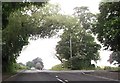
1
Milepost Stanthorne Near Winsford
Milepost at the junction of A54 and Birch Lane Near Stanthorne, Winsford.
Image: © David Marten
Taken: 3 Dec 2006
0.05 miles
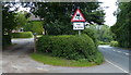
2
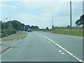
Junction of A54 and Birch Lane
Junction of A54 and Birch Lane from position of Milepost.
Image: © David Marten
Taken: 3 Dec 2006
0.11 miles
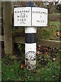
4
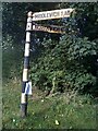
Direction Sign ? Signpost at the A54/A533 junction in Stanthorne and Wimboldsley parish
Located near Bostock House on the northwest side of the Y junction of the A54 Chester Road/Middlewich Road and the A533 Northwich Road in Stanthorne and Wimboldsley parish. 3 arms and lost finial. It dates from the 1920s/1930s. This 2010 photo shows it after repainting https://www.flickr.com/photos/21940361@N08/4964272152/.
Milestone Society National ID: CH_SJ6966B
Image: © John V Nicholls
Taken: Unknown
0.20 miles
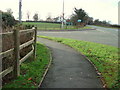
5
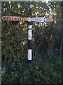
Direction Sign ? Signpost on Coalpit Lane near Stanthorne
Located near Mill Farm on the southeast side of the T junction of Coalpit Lane and Birch Lane in Stanthorne and Wimboldsley parish. 3 arms and pawn finial. It dates to around the first decade of the 20th century but the arm towards Northwich is a replacement. The N R / D C shield on the pillar represents Northwich Rural District Council.
Milestone Society National ID: CH_SJ6966A
Image: © John V Nicholls
Taken: Unknown
0.21 miles