IMAGES TAKEN NEAR TO
Northwich Road, MIDDLEWICH, CW10 9JH
Introduction
This page details the photographs taken nearby to Northwich Road, CW10 9JH by members of the Geograph project.
The Geograph project started in 2005 with the aim of publishing, organising and preserving representative images for every square kilometre of Great Britain, Ireland and the Isle of Man.

There are currently over 7.5m images from over14,400 individuals and you can help contribute to the project by visiting https://www.geograph.org.uk
Image Map
Images are licensed for reuse under creativecommons.org/licenses/by-sa/2.0
Notes
- Clicking on the map will re-center to the selected point.
- The higher the marker number, the further away the image location is from the centre of the postcode.
Image Listing (19 Images Found)
Images are licensed for reuse under creativecommons.org/licenses/by-sa/2.0
Image
Details
Distance
3

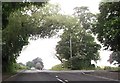
Oak tree in autumn colours -Coalpit Lane
Image: © Dr Duncan Pepper
Taken: 12 Nov 2011
0.07 miles
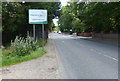
4
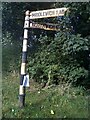
Direction Sign ? Signpost at the A54/A533 junction in Stanthorne and Wimboldsley parish
Located near Bostock House on the northwest side of the Y junction of the A54 Chester Road/Middlewich Road and the A533 Northwich Road in Stanthorne and Wimboldsley parish. 3 arms and lost finial. It dates from the 1920s/1930s. This 2010 photo shows it after repainting https://www.flickr.com/photos/21940361@N08/4964272152/.
Milestone Society National ID: CH_SJ6966B
Image: © John V Nicholls
Taken: Unknown
0.07 miles


7
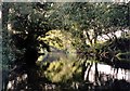
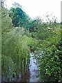
River Dane
At this point it appears that the river is flowing in a wood but the trees only grow at the rivers edge and are not shown on the O.S. map.
Image: © Stephen Burton
Taken: 19 Jul 2005
0.15 miles
8
River Wheelock
River Wheelock - view upstream from the Middlewich Road (A54) bridge. This is just upstream of the confluence of the River Wheelock with the River Dane. Middlewich has developed between the two rivers. The Wheelock drains from a series of small brooks and flashes to the NE of Crewe - modest companion to the Dane, which has much more dramatic origins high in the Pennine hills. At this point the Wheelock forms the boundary between the parishes of Stanthorne and Middlewich - and thus between the boroughs of Vale Royal and Congleton.
Image: © Mike Harris
Taken: 19 May 2007
0.15 miles
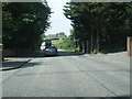
10
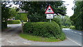
A54 Chester Road in Middlewich
Entering Cheshire East from Cheshire West and Chester.
Image: © Mat Fascione
Taken: 15 Jul 2015
0.16 miles