IMAGES TAKEN NEAR TO
Garfit Street, MIDDLEWICH, CW10 9EG
Introduction
This page details the photographs taken nearby to Garfit Street, CW10 9EG by members of the Geograph project.
The Geograph project started in 2005 with the aim of publishing, organising and preserving representative images for every square kilometre of Great Britain, Ireland and the Isle of Man.

There are currently over 7.5m images from over14,400 individuals and you can help contribute to the project by visiting https://www.geograph.org.uk
Image Map
Images are licensed for reuse under creativecommons.org/licenses/by-sa/2.0
Notes
- Clicking on the map will re-center to the selected point.
- The higher the marker number, the further away the image location is from the centre of the postcode.
Image Listing (80 Images Found)
Images are licensed for reuse under creativecommons.org/licenses/by-sa/2.0
Image
Details
Distance
2
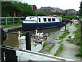
Big Lock, Middlewich
Heading North on the Trent and Mersey Canal, Big Lock is the last set of locks on leaving the town.
Image: © Gwyn Jones
Taken: 28 Jul 2004
0.09 miles
3
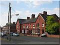
Brookland Villas, New King Street
Dark red brick residential architecture.
The other interesting feature of this photo is the wooden pole radiating telephone cables to the surrounding houses. Once a common sight, by 2010 they had become rare, as underground fibreoptic cables had largely replaced overhead copper.
Image: © Stephen Craven
Taken: 27 Jun 2010
0.09 miles
4
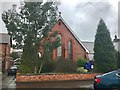
St Mary's Roman Catholic Church, Middlewich
Image: © Jonathan Hutchins
Taken: 18 Mar 2017
0.11 miles
5
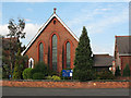
St Mary's Church, Middlewich
A Roman Catholic church on King Street
Image: © Stephen Craven
Taken: 27 Jun 2010
0.11 miles
6
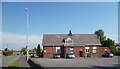
St Mary's Parish Centre
Church hall on King Street.
Image: © Des Blenkinsopp
Taken: 19 Jun 2013
0.11 miles
7
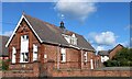
Middlewich, Parish Centre
There is a benchmark cut into the south-east facing wall of the Parish Centre, and it is cut into the 2nd and 3rd course of bricks. The building was previously used as a school until the mid '90s.
Image: © Mel Towler
Taken: 8 Oct 2022
0.13 miles
8
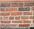
Middlewich, Parish Centre
The benchmark is cut into the south-east facing wall of the Parish Centre. The building was previously used as a school until the mid '90s.
Image: © Mel Towler
Taken: 8 Oct 2022
0.13 miles
9
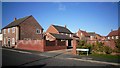
Pennymoor Drive, Middlewich
New housing on the north edge of town.
Image: © Des Blenkinsopp
Taken: 13 Feb 2014
0.13 miles