IMAGES TAKEN NEAR TO
Wimboldsley, MIDDLEWICH, CW10 0LW
Introduction
This page details the photographs taken nearby to CW10 0LW by members of the Geograph project.
The Geograph project started in 2005 with the aim of publishing, organising and preserving representative images for every square kilometre of Great Britain, Ireland and the Isle of Man.

There are currently over 7.5m images from over14,400 individuals and you can help contribute to the project by visiting https://www.geograph.org.uk
Image Map
Images are licensed for reuse under creativecommons.org/licenses/by-sa/2.0
Notes
- Clicking on the map will re-center to the selected point.
- The higher the marker number, the further away the image location is from the centre of the postcode.
Image Listing (7 Images Found)
Images are licensed for reuse under creativecommons.org/licenses/by-sa/2.0
Image
Details
Distance
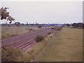
3
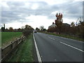
West Coast main Line near Wimboldsley Hall
Looking north west from the bridge on Nantwich Road (A530).
Image: © JThomas
Taken: 5 Nov 2016
0.17 miles
6
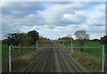
West Coast Main Line at Wimboldsley in BR days
The four-track section of line between Crewe and Winsford, seen from the A530 bridge. A class 86 electric locomotive approaches in the distance with a down (northbound) passenger train.
Image: © Stephen Craven
Taken: 1 Jul 1979
0.24 miles
7
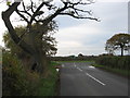
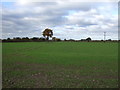
Junction of the A530 Nantwich Road with the lane to Occlestone Green
Image: © Dr Duncan Pepper
Taken: 17 Nov 2011
0.24 miles