IMAGES TAKEN NEAR TO
Joness Lane, MIDDLEWICH, CW10 0JY
Introduction
This page details the photographs taken nearby to Joness Lane, CW10 0JY by members of the Geograph project.
The Geograph project started in 2005 with the aim of publishing, organising and preserving representative images for every square kilometre of Great Britain, Ireland and the Isle of Man.

There are currently over 7.5m images from over14,400 individuals and you can help contribute to the project by visiting https://www.geograph.org.uk
Image Map
Images are licensed for reuse under creativecommons.org/licenses/by-sa/2.0
Notes
- Clicking on the map will re-center to the selected point.
- The higher the marker number, the further away the image location is from the centre of the postcode.
Image Listing (15 Images Found)
Images are licensed for reuse under creativecommons.org/licenses/by-sa/2.0
Image
Details
Distance
1
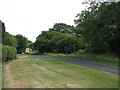
Walkers Green
Jones's Lane, with a wide verge, approaching the houses on the bend at Walkers Green.
Image: © Stephen Craven
Taken: 27 Jun 2010
0.08 miles
2
Horses, Jones's Lane, Sproston
On the Dawfields estate.
Image: © Stephen Craven
Taken: 29 Mar 2016
0.10 miles
3
Sharp bend on Jones's Lane, Sproston
The road crosses a brook as it goes round the bend.
Image: © Stephen Craven
Taken: 29 Mar 2016
0.13 miles
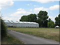
4
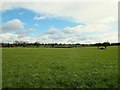
Grassland byJones's Lane, Sproston
See Image for the same field in summer.
Image: © Stephen Craven
Taken: 29 Mar 2016
0.15 miles
5
Stable building, Jones's Lane, Sproston
I had forgotten that I had taken a photo here in 2010 Image although from a different angle.
Image: © Stephen Craven
Taken: 29 Mar 2016
0.15 miles
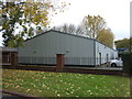
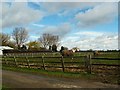
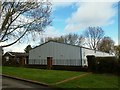
7
Metal shed at Dawfields
A large agricultural shed.
Although this looks like a photo taken on private land it was actually taken holding the camera over a gate from the public road.
Image: © Stephen Craven
Taken: 27 Jun 2010
0.16 miles
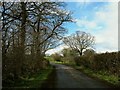
8
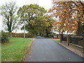
Minor road, Dawfields
Heading north west towards Sproston.
Image: © JThomas
Taken: 29 Oct 2016
0.19 miles
9
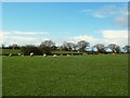
Sheep in a field byJones's Lane, Sproston
Knightshulme Farm in the distance.
Image: © Stephen Craven
Taken: 29 Mar 2016
0.20 miles
10
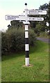
Old Direction Sign - Signpost by Jones's Lane, Walkers Green
Pawn finial - 4 arms; Cheshire CC post by the UC road, in parish of Middlewich (Congleton District), Cledford Lane junction with Jones's Lane, Walkers Green.
To be surveyed
Milestone Society National ID: CH_SJ7365A
Image: © Milestone Society
Taken: Unknown
0.20 miles