IMAGES TAKEN NEAR TO
Wellsborough Road, ATHERSTONE, CV9 3RF
Introduction
This page details the photographs taken nearby to Wellsborough Road, CV9 3RF by members of the Geograph project.
The Geograph project started in 2005 with the aim of publishing, organising and preserving representative images for every square kilometre of Great Britain, Ireland and the Isle of Man.

There are currently over 7.5m images from over14,400 individuals and you can help contribute to the project by visiting https://www.geograph.org.uk
Image Map
Images are licensed for reuse under creativecommons.org/licenses/by-sa/2.0
Notes
- Clicking on the map will re-center to the selected point.
- The higher the marker number, the further away the image location is from the centre of the postcode.
Image Listing (6 Images Found)
Images are licensed for reuse under creativecommons.org/licenses/by-sa/2.0
Image
Details
Distance
1
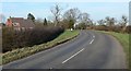
North along the B585 Wellsborough Road
The house is part of Home Farm.
Image: © Mat Fascione
Taken: 9 Feb 2008
0.07 miles
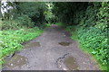
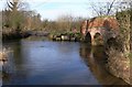
3
Ford at Sheepy Parva
This byway ford is found at Sheepy Parva.
Image: © John Walton
Taken: 4 Jun 2012
0.14 miles
4
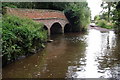
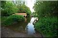
Lovett's Bridge
This small bridge carries a footpath across a deep ford.
Image: © Mat Fascione
Taken: 9 Feb 2008
0.14 miles