IMAGES TAKEN NEAR TO
Burton Road, ATHERSTONE, CV9 3PR
Introduction
This page details the photographs taken nearby to Burton Road, CV9 3PR by members of the Geograph project.
The Geograph project started in 2005 with the aim of publishing, organising and preserving representative images for every square kilometre of Great Britain, Ireland and the Isle of Man.

There are currently over 7.5m images from over14,400 individuals and you can help contribute to the project by visiting https://www.geograph.org.uk
Image Map
Images are licensed for reuse under creativecommons.org/licenses/by-sa/2.0
Notes
- Clicking on the map will re-center to the selected point.
- The higher the marker number, the further away the image location is from the centre of the postcode.
Image Listing (20 Images Found)
Images are licensed for reuse under creativecommons.org/licenses/by-sa/2.0
Image
Details
Distance
4
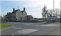
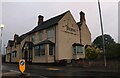
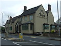
Main Road in Twycross, Leicestershire
The Curzon Arms public house is the building opposite the roundabout.
Image: © Mat Fascione
Taken: 9 Feb 2008
0.09 miles
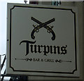
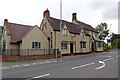
7
Turpins Bar & Grill, Twycross
On Main Road.
Formerly The Curzon Arms. See Image
Image: © JThomas
Taken: 23 May 2015
0.10 miles
8
Twycross-Turpins Bar And Grill
On Main Road.
Image: © Ian Rob
Taken: 29 Aug 2019
0.10 miles