IMAGES TAKEN NEAR TO
Riverside, ATHERSTONE, CV9 3LQ
Introduction
This page details the photographs taken nearby to Riverside, CV9 3LQ by members of the Geograph project.
The Geograph project started in 2005 with the aim of publishing, organising and preserving representative images for every square kilometre of Great Britain, Ireland and the Isle of Man.

There are currently over 7.5m images from over14,400 individuals and you can help contribute to the project by visiting https://www.geograph.org.uk
Image Map
Images are licensed for reuse under creativecommons.org/licenses/by-sa/2.0
Notes
- Clicking on the map will re-center to the selected point.
- The higher the marker number, the further away the image location is from the centre of the postcode.
Image Listing (32 Images Found)
Images are licensed for reuse under creativecommons.org/licenses/by-sa/2.0
Image
Details
Distance
1
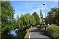
Witherley Riverside
Looking downstream on The River Anker towards St Peter's Church.
Image: © Ian Rob
Taken: 29 Aug 2019
0.04 miles
2
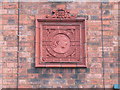
Victoria's Jubilee
Fired tile plaque on the wall of a house, commemorating Queen Victoria's Jubilee in 1897 - listing all of the countries of the empire.
Image: © Eirian Evans
Taken: 3 Apr 2010
0.06 miles
3
Witherley Primary School
The school is right next to St Peter's Church.
Image: © Eirian Evans
Taken: 3 Apr 2010
0.06 miles
4
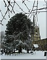
Monkey Puzzle tree in front of St Peter's
A fine Monkey Puzzle (Araucaria araucana) partly obscures the Grade I listed St Peter's church in the village of Witherley. This village is just inside Leicestershire while the nearby town of Atherstone is in Warwickshire, the River Anker which runs beside the church being the county boundary at this point. See also Image] Image] and Image]
Church EH listing here http://list.english-heritage.org.uk/resultsingle.aspx?uid=1188486&searchtype=mapsearch
Image: © Rob Farrow
Taken: 23 Mar 2013
0.06 miles
5
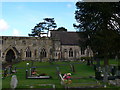
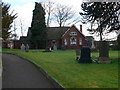
Churchyard, St Peter's Church Witherley
Image: © Eirian Evans
Taken: 3 Apr 2010
0.07 miles
6
St Peter's Church, Witherley
Early C14, with a C15 west tower and a chancel of 1858 by Robert Jennings of Atherstone. http://www.imagesofengland.org.uk/Details/Default.aspx?id=188265&mode=quick. The church stands alongside the river Anker.
Image: © Eirian Evans
Taken: 3 Apr 2010
0.07 miles
7
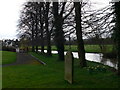
The River Anker, Witherley
The river Anker forms the boundary between Warwickshire and Leicestershire here in Witherley. The photo is taken looking southward in the churchyard of St Peter's Church.
Image: © Eirian Evans
Taken: 3 Apr 2010
0.07 miles
8
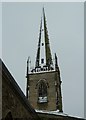
Spire - St Peter's, Witherley
A close-up view of the fine sharply-pointed octagonal spire of St Peter's in Witherley, with one of its eight facets picked out in snow.
See also Image] Image] and Image]
Image: © Rob Farrow
Taken: 23 Mar 2013
0.08 miles
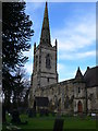
9
Church of St Peter, Witherley
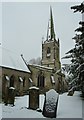
A beautiful church in a lovely riverside setting. St Peter's dates from the early C14th with a C15th tower and remarkable spire. The chancel is much later dating from 1858. The snow emphasised the octagonal cross-section of the spire.
See also Image] Image] and Image]
The church is EH Grade I listed http://list.english-heritage.org.uk/resultsingle.aspx?uid=1188486&searchtype=mapsearch
Image: © Rob Farrow
Taken: 23 Mar 2013
0.08 miles
10
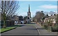
St Peters Avenue, Witherley
With the Parish Church of Witherley in the background.
Image: © Mat Fascione
Taken: 9 Feb 2008
0.08 miles