IMAGES TAKEN NEAR TO
Kendall Drive, ATHERSTONE, CV9 3FF
Introduction
This page details the photographs taken nearby to Kendall Drive, CV9 3FF by members of the Geograph project.
The Geograph project started in 2005 with the aim of publishing, organising and preserving representative images for every square kilometre of Great Britain, Ireland and the Isle of Man.

There are currently over 7.5m images from over14,400 individuals and you can help contribute to the project by visiting https://www.geograph.org.uk
Image Map
Images are licensed for reuse under creativecommons.org/licenses/by-sa/2.0
Notes
- Clicking on the map will re-center to the selected point.
- The higher the marker number, the further away the image location is from the centre of the postcode.
Image Listing (18 Images Found)
Images are licensed for reuse under creativecommons.org/licenses/by-sa/2.0
Image
Details
Distance
1
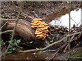
Wood fungi
Fungi growing on a log in small wood in Cinder Lane, Austrey.
Image: © Colin Lea
Taken: 13 Jan 2007
0.03 miles
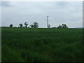
3
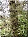
Prevailing wind
Horizontal growths on tree in small wood at the side of Cinder Lane, Austrey.
Image: © Colin Lea
Taken: 25 Mar 2008
0.04 miles
4
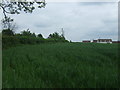
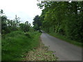
Crop field and hedgerow
Looking south towards Hall Fields Farm.
Image: © JThomas
Taken: 23 May 2015
0.09 miles
7
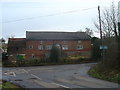
Gamble Croft
Old house for sale and uninhabited at end of Cinder Lane, Austrey
Image: © Colin Lea
Taken: 24 Jan 2009
0.10 miles
8
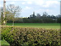
Over yonder
Austrey's St. Nicholas Church on the horizon
Image: © cris sloan
Taken: 8 Apr 2007
0.12 miles
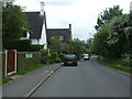
9
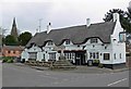
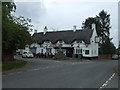
Bird In Hand
A 300 year old thatched pub on Main Road in Austrey, Warwickshire. The spire of St Nicholas Church is visible to the left.
Image: © Mat Fascione
Taken: 24 Mar 2008
0.13 miles