IMAGES TAKEN NEAR TO
Paget Rise, ATHERSTONE, CV9 3EY
Introduction
This page details the photographs taken nearby to Paget Rise, CV9 3EY by members of the Geograph project.
The Geograph project started in 2005 with the aim of publishing, organising and preserving representative images for every square kilometre of Great Britain, Ireland and the Isle of Man.

There are currently over 7.5m images from over14,400 individuals and you can help contribute to the project by visiting https://www.geograph.org.uk
Image Map
Images are licensed for reuse under creativecommons.org/licenses/by-sa/2.0
Notes
- Clicking on the map will re-center to the selected point.
- The higher the marker number, the further away the image location is from the centre of the postcode.
Image Listing (6 Images Found)
Images are licensed for reuse under creativecommons.org/licenses/by-sa/2.0
Image
Details
Distance
1
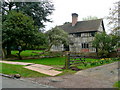
Timber-framed house in Austrey
On Warton Lane.
Image: © Jonathan Billinger
Taken: 16 Apr 2009
0.07 miles
2
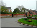
Junction in Austrey
The village centre is to the right.
Image: © Jonathan Billinger
Taken: 16 Apr 2009
0.13 miles
3

Entering Austrey
Heading north east on Warton Lane.
Image: © JThomas
Taken: 23 May 2015
0.18 miles
4
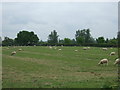
Grazing west of Austrey
South of Newton Lane.
Image: © JThomas
Taken: 23 May 2015
0.21 miles