IMAGES TAKEN NEAR TO
Farm Lane, ATHERSTONE, CV9 3DR
Introduction
This page details the photographs taken nearby to Farm Lane, CV9 3DR by members of the Geograph project.
The Geograph project started in 2005 with the aim of publishing, organising and preserving representative images for every square kilometre of Great Britain, Ireland and the Isle of Man.

There are currently over 7.5m images from over14,400 individuals and you can help contribute to the project by visiting https://www.geograph.org.uk
Image Map
Images are licensed for reuse under creativecommons.org/licenses/by-sa/2.0
Notes
- Clicking on the map will re-center to the selected point.
- The higher the marker number, the further away the image location is from the centre of the postcode.
Image Listing (6 Images Found)
Images are licensed for reuse under creativecommons.org/licenses/by-sa/2.0
Image
Details
Distance
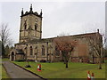
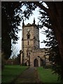
2
Grendon Church
All Saints, some distance from the village.
Image: © Ian Rob
Taken: 10 Aug 2022
0.15 miles
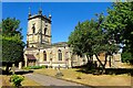
3
All Saints, Grendon from the main gate
Lots of information about the church here -
http://www.british-history.ac.uk/report.asp?compid=42659#s3
Image: © Rob Farrow
Taken: 22 Jan 2006
0.16 miles
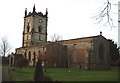
4
All Saints, Grendon - The Tower
Hidden up a little lane, within the grounds of an old hall is this fine old church.
Image: © Rob Farrow
Taken: 22 Jan 2006
0.16 miles
5
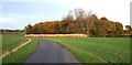
Drive to Grendon House Farm
Grendon House Farm can just be seen in the distance to the left of the plantation which dominates the picture.
Image: © Rob Farrow
Taken: 25 Nov 2006
0.22 miles
6
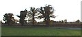
Roadside Trees
Considering how late in the autumn it is these trees alongside the road from Grendon to Warton & Polesworth still retain a lot of their leaves - though some of the greenery is due to ivy clambering up their trunks.
Image: © Rob Farrow
Taken: 25 Nov 2006
0.24 miles