IMAGES TAKEN NEAR TO
Grendon, ATHERSTONE, CV9 3DP
Introduction
This page details the photographs taken nearby to CV9 3DP by members of the Geograph project.
The Geograph project started in 2005 with the aim of publishing, organising and preserving representative images for every square kilometre of Great Britain, Ireland and the Isle of Man.

There are currently over 7.5m images from over14,400 individuals and you can help contribute to the project by visiting https://www.geograph.org.uk
Image Map
Images are licensed for reuse under creativecommons.org/licenses/by-sa/2.0
Notes
- Clicking on the map will re-center to the selected point.
- The higher the marker number, the further away the image location is from the centre of the postcode.
Image Listing (6 Images Found)
Images are licensed for reuse under creativecommons.org/licenses/by-sa/2.0
Image
Details
Distance
1
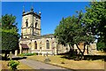
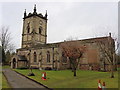
Grendon Church
All Saints, some distance from the village.
Image: © Ian Rob
Taken: 10 Aug 2022
0.06 miles
2
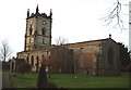
All Saints, Grendon from the main gate
Lots of information about the church here -
http://www.british-history.ac.uk/report.asp?compid=42659#s3
Image: © Rob Farrow
Taken: 22 Jan 2006
0.06 miles
3
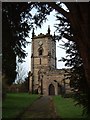
All Saints, Grendon - The Tower
Hidden up a little lane, within the grounds of an old hall is this fine old church.
Image: © Rob Farrow
Taken: 22 Jan 2006
0.06 miles
5
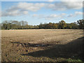
Stubble field near Grendon
The hedge in shadow across the picture is by the B5000 Grendon Road. The specks right of centre are road signs. This countryside is a relic of the Grendon Hall estate, seat of the Chetwynd family. Jean Wood, in 'Old Polesworth', records that the Hall was bought by the Browne family, dismantled in 1931, shipped over to Georgia USA and rebuilt to provide a home for a wealthy family there. Two other Warwickshire houses suffered the same fate: Priory House in Warwick and Hams Hall near Coleshill.
Image: © Robin Stott
Taken: 11 Nov 2012
0.22 miles
6
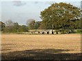
Mediaeval bridge across the River Anker south of Grendon Park
It might once have carried a road to vanished Grendon Hall; now it appears to carry a lightly-used farm track.
Image: © Robin Stott
Taken: 11 Nov 2012
0.22 miles