IMAGES TAKEN NEAR TO
Lister Road, ATHERSTONE, CV9 3BU
Introduction
This page details the photographs taken nearby to Lister Road, CV9 3BU by members of the Geograph project.
The Geograph project started in 2005 with the aim of publishing, organising and preserving representative images for every square kilometre of Great Britain, Ireland and the Isle of Man.

There are currently over 7.5m images from over14,400 individuals and you can help contribute to the project by visiting https://www.geograph.org.uk
Image Map
Images are licensed for reuse under creativecommons.org/licenses/by-sa/2.0
Notes
- Clicking on the map will re-center to the selected point.
- The higher the marker number, the further away the image location is from the centre of the postcode.
Image Listing (6 Images Found)
Images are licensed for reuse under creativecommons.org/licenses/by-sa/2.0
Image
Details
Distance

3
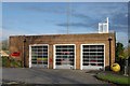
Atherstone fire station
Atherstone fire station, Kings Avenue, Atherstone, Warwickshire
Image: © Kevin Hale
Taken: 25 Nov 2006
0.23 miles
5
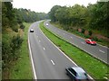
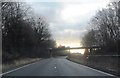
Atherstone By-Pass
The A5 curves round the north side of Atherstone town centre.
Image: © Stephen McKay
Taken: 15 Oct 2006
0.25 miles
6
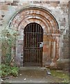
Baddesley porch
North side of Atherstone church. Private entrance for the Bracebridge family of the adjacent Atherstone Hall (now demolished). Porch is made from the recycled doorway of the old (Saxon) church at Baddesley Ensor.
Image: © John Parton
Taken: Unknown
0.25 miles