IMAGES TAKEN NEAR TO
Meadow Road, ATHERSTONE, CV9 2NP
Introduction
This page details the photographs taken nearby to Meadow Road, CV9 2NP by members of the Geograph project.
The Geograph project started in 2005 with the aim of publishing, organising and preserving representative images for every square kilometre of Great Britain, Ireland and the Isle of Man.

There are currently over 7.5m images from over14,400 individuals and you can help contribute to the project by visiting https://www.geograph.org.uk
Image Map
Images are licensed for reuse under creativecommons.org/licenses/by-sa/2.0
Notes
- Clicking on the map will re-center to the selected point.
- The higher the marker number, the further away the image location is from the centre of the postcode.
Image Listing (4 Images Found)
Images are licensed for reuse under creativecommons.org/licenses/by-sa/2.0
Image
Details
Distance
1
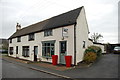
Cottages at Hurley Common
One of these cottages has been converted into a unisex hairdressing and beauty shop.
Image: © Mick Malpass
Taken: 11 Dec 2011
0.19 miles
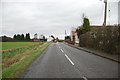
2
Cottages in Hurley Common
Looking SSW through the settlement which mainly consists of several rows of roadside cottages.
Image: © David Stowell
Taken: 29 Jul 2006
0.20 miles
4
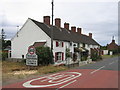
Hurley Common
A row of cottages at the southern end of the small settlement at Hurley Common.
Image: © David Stowell
Taken: 29 Jul 2006
0.25 miles