IMAGES TAKEN NEAR TO
Baxterley, ATHERSTONE, CV9 2LN
Introduction
This page details the photographs taken nearby to CV9 2LN by members of the Geograph project.
The Geograph project started in 2005 with the aim of publishing, organising and preserving representative images for every square kilometre of Great Britain, Ireland and the Isle of Man.

There are currently over 7.5m images from over14,400 individuals and you can help contribute to the project by visiting https://www.geograph.org.uk
Image Map
Images are licensed for reuse under creativecommons.org/licenses/by-sa/2.0
Notes
- Clicking on the map will re-center to the selected point.
- The higher the marker number, the further away the image location is from the centre of the postcode.
Image Listing (2 Images Found)
Images are licensed for reuse under creativecommons.org/licenses/by-sa/2.0
Image
Details
Distance
1
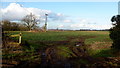
Farmland and muddy footpath
A crop of rape to the west of Rose Farm.
Image: © Jonathan Billinger
Taken: 7 Feb 2017
0.12 miles
2
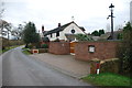
Steam Mill Cottage near Baxterley
The renovation work that has been done on this cottage is very impressive.
Image: © Mick Malpass
Taken: 11 Dec 2011
0.14 miles