IMAGES TAKEN NEAR TO
Merevale Lane, ATHERSTONE, CV9 2LA
Introduction
This page details the photographs taken nearby to Merevale Lane, CV9 2LA by members of the Geograph project.
The Geograph project started in 2005 with the aim of publishing, organising and preserving representative images for every square kilometre of Great Britain, Ireland and the Isle of Man.

There are currently over 7.5m images from over14,400 individuals and you can help contribute to the project by visiting https://www.geograph.org.uk
Image Map
Images are licensed for reuse under creativecommons.org/licenses/by-sa/2.0
Notes
- Clicking on the map will re-center to the selected point.
- The higher the marker number, the further away the image location is from the centre of the postcode.
Image Listing (2 Images Found)
Images are licensed for reuse under creativecommons.org/licenses/by-sa/2.0
Image
Details
Distance
1
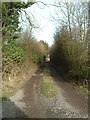
Track to cottage at Colliery Farm
The building glimpsed at the end of this track is not Colliery Farm itself, but a cottage adjacent to it.
Image: © Rob Farrow
Taken: 22 Jan 2006
0.12 miles
2
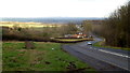
Merevale Lane
B4116 looking north-east over a post-industrial landscape. Colliery Farm at the bottom of the hill.
Image: © Jonathan Billinger
Taken: 7 Feb 2017
0.19 miles