IMAGES TAKEN NEAR TO
Foul End, ATHERSTONE, CV9 2JW
Introduction
This page details the photographs taken nearby to Foul End, CV9 2JW by members of the Geograph project.
The Geograph project started in 2005 with the aim of publishing, organising and preserving representative images for every square kilometre of Great Britain, Ireland and the Isle of Man.

There are currently over 7.5m images from over14,400 individuals and you can help contribute to the project by visiting https://www.geograph.org.uk
Image Map
Images are licensed for reuse under creativecommons.org/licenses/by-sa/2.0
Notes
- Clicking on the map will re-center to the selected point.
- The higher the marker number, the further away the image location is from the centre of the postcode.
Image Listing (8 Images Found)
Images are licensed for reuse under creativecommons.org/licenses/by-sa/2.0
Image
Details
Distance
1
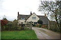
Orchard Cottage, Foul End
I think it says Orchard Cottage, but the sign is in old script and a bit faded, so my apologies if I am wrong.
Image: © Mick Malpass
Taken: 11 Dec 2011
0.07 miles
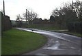
3
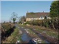
Farm track at Foul End
The track is also a public byway and includes part of the Heart of England Way.
Image: © Bill Boaden
Taken: 13 Oct 2018
0.10 miles
4
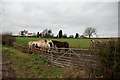
Looking in the direction of Foul End
The Ponies are tucking into some very welcome hay, I hope the one on the right got some.
Image: © Mick Malpass
Taken: 11 Dec 2011
0.13 miles
5
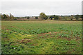
Farmland at Foul End
The crop looks a little patchy.
Image: © Bill Boaden
Taken: 13 Oct 2018
0.13 miles
6
..and a pheasant in a Foul End
A pheasant pops into Foul End, Warwickshire.
Image: © Richard Harrison
Taken: 20 Jan 2006
0.15 miles
7
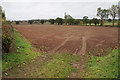
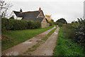
Field entrance near Foul End
The field has been prepared for a winter crop.
Image: © Bill Boaden
Taken: 13 Oct 2018
0.17 miles
8
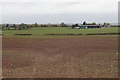
Planted field near Foul End
Tib Hall Farm is visible further away.
Image: © Bill Boaden
Taken: 13 Oct 2018
0.18 miles