IMAGES TAKEN NEAR TO
Hurley Lane, ATHERSTONE, CV9 2JJ
Introduction
This page details the photographs taken nearby to Hurley Lane, CV9 2JJ by members of the Geograph project.
The Geograph project started in 2005 with the aim of publishing, organising and preserving representative images for every square kilometre of Great Britain, Ireland and the Isle of Man.

There are currently over 7.5m images from over14,400 individuals and you can help contribute to the project by visiting https://www.geograph.org.uk
Image Map
Images are licensed for reuse under creativecommons.org/licenses/by-sa/2.0
Notes
- Clicking on the map will re-center to the selected point.
- The higher the marker number, the further away the image location is from the centre of the postcode.
Image Listing (8 Images Found)
Images are licensed for reuse under creativecommons.org/licenses/by-sa/2.0
Image
Details
Distance
1
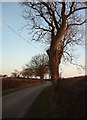
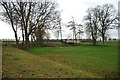
Foul End Lane
Despite its name, this is a very pleasant rural area !
Image: © Rob Farrow
Taken: 21 Jan 2006
0.13 miles
2
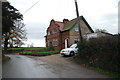
Semi Detached Cottages near to Flanders Hall
Image: © Mick Malpass
Taken: 11 Dec 2011
0.15 miles
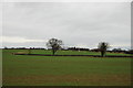
3
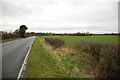
Looking towards the B4098 Coventry Road near Kingsbury
Image: © Mick Malpass
Taken: 11 Dec 2011
0.17 miles
4
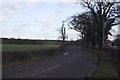
Crow Hall
A view down the road towards Crow Hall on the right and the Heart of England way on the left.
Image: © Richard Harrison
Taken: 20 Jan 2006
0.19 miles
5
Across a paddock to Flanders Hall Farm
Image: © Mick Malpass
Taken: 11 Dec 2011
0.23 miles
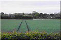
6
A view over fields towards the MOD rifle range in Kingsbury
The red flag is flying so the range must be in use.
Image: © Mick Malpass
Taken: 11 Dec 2011
0.24 miles
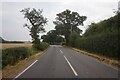
8
Wheat field by Coventry Road
The hedge to the right shows the line of the lane to Hurley.
Image: © Bill Boaden
Taken: 25 May 2019
0.25 miles