IMAGES TAKEN NEAR TO
Knowle Hill, ATHERSTONE, CV9 2JE
Introduction
This page details the photographs taken nearby to Knowle Hill, CV9 2JE by members of the Geograph project.
The Geograph project started in 2005 with the aim of publishing, organising and preserving representative images for every square kilometre of Great Britain, Ireland and the Isle of Man.

There are currently over 7.5m images from over14,400 individuals and you can help contribute to the project by visiting https://www.geograph.org.uk
Image Map
Images are licensed for reuse under creativecommons.org/licenses/by-sa/2.0
Notes
- Clicking on the map will re-center to the selected point.
- The higher the marker number, the further away the image location is from the centre of the postcode.
Image Listing (9 Images Found)
Images are licensed for reuse under creativecommons.org/licenses/by-sa/2.0
Image
Details
Distance
1
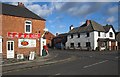
Hurley post office
A view of Hurley post office in well...Hurley!
Image: © Richard Harrison
Taken: 20 Jan 2006
0.02 miles
2
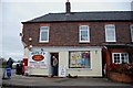
Hurley Post Office from a different angle
I wonder if the corner was cut off the building to accommodate the post box, so that it could be emptied from inside the shop.
Image: © Mick Malpass
Taken: 11 Dec 2011
0.04 miles
3
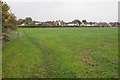
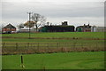
Footpath to Hurley
Ahead are buildings lining Knowle Hill which is the main road through Hurley.
Image: © Bill Boaden
Taken: 13 Oct 2018
0.08 miles
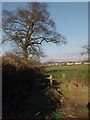
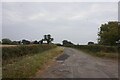
5
Looking over fields to Camp Farm near Hurley
Image: © Mick Malpass
Taken: 11 Dec 2011
0.16 miles
9

Camp Farm, Hurley
The low sun illuminates the render on Camp Farm. It is up a triangular side road off the main lane to Hurley.
Image: © Rob Farrow
Taken: 21 Jan 2006
0.24 miles