IMAGES TAKEN NEAR TO
Hipsley Lane, ATHERSTONE, CV9 2HS
Introduction
This page details the photographs taken nearby to Hipsley Lane, CV9 2HS by members of the Geograph project.
The Geograph project started in 2005 with the aim of publishing, organising and preserving representative images for every square kilometre of Great Britain, Ireland and the Isle of Man.

There are currently over 7.5m images from over14,400 individuals and you can help contribute to the project by visiting https://www.geograph.org.uk
Image Map
Images are licensed for reuse under creativecommons.org/licenses/by-sa/2.0
Notes
- Clicking on the map will re-center to the selected point.
- The higher the marker number, the further away the image location is from the centre of the postcode.
Image Listing (19 Images Found)
Images are licensed for reuse under creativecommons.org/licenses/by-sa/2.0
Image
Details
Distance
1
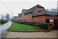
Latimer's Place in Hipsley Lane near the junction with Main Road
Image: © Mick Malpass
Taken: 11 Dec 2011
0.03 miles
2
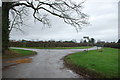
Road Junction at the North end of Hipsley Lane with Main Road
Taken from the driveway of Latimer's Place
Image: © Mick Malpass
Taken: 11 Dec 2011
0.05 miles
3
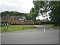
North end of Hipsley Lane
At its junction with Main Road between Baxterley and Wood End. On the left is a new house called Latimer's Place, with Baxterley parish church in the background.
Image: © Robin Stott
Taken: 14 Aug 2011
0.05 miles
4
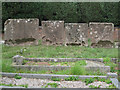
Memorials to members of the Glover family
In Baxterley churchyard it is noticeable how several generations of the same family are buried together. The third stone from the left bears the date 1643: the time of the first Civil War.
"The church has a west front and bell turret built by Hugh Glover, son of Robert, burnt as a heretic at Coventry in 1555" — from the 1979 Shell Guide to Warwickshire by Douglas Hickman.
Image: © Robin Stott
Taken: 14 Aug 2011
0.06 miles
5
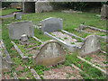
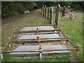
Memorials to members of the Knowles family
In Baxterley churchyard it is noticeable how several generations of the same family are buried together.
This low-level Art Deco style of memorial seems to have appeared in the 1920s and was still being used in the 1950s.
Image: © Robin Stott
Taken: 14 Aug 2011
0.07 miles
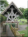
7
Approach to Baxterley parish church
The building on the right was a schoolroom. A tablet dated 1839 on the far gable wall is inscribed with a phrase from the gospel of St John, 'Feed my lambs'.
Image: © Robin Stott
Taken: 14 Aug 2011
0.07 miles
8
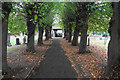
Pathway from Baxterley Church
The main route from the church, lined by linden trees.
Image: © Bill Boaden
Taken: 12 Oct 2018
0.07 miles
9
Memorials to members of the Redhead family
In Baxterley churchyard it is noticeable how several generations of the same family are buried together.
Image: © Robin Stott
Taken: 14 Aug 2011
0.07 miles
10
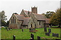
Baxterley Church
In a location some distance from the main part of the village. It is viewed on a very dull day.
Image: © Bill Boaden
Taken: 12 Oct 2018
0.07 miles