IMAGES TAKEN NEAR TO
Westwood Road, ATHERSTONE, CV9 2AZ
Introduction
This page details the photographs taken nearby to Westwood Road, CV9 2AZ by members of the Geograph project.
The Geograph project started in 2005 with the aim of publishing, organising and preserving representative images for every square kilometre of Great Britain, Ireland and the Isle of Man.

There are currently over 7.5m images from over14,400 individuals and you can help contribute to the project by visiting https://www.geograph.org.uk
Image Map
Images are licensed for reuse under creativecommons.org/licenses/by-sa/2.0
Notes
- Clicking on the map will re-center to the selected point.
- The higher the marker number, the further away the image location is from the centre of the postcode.
Image Listing (147 Images Found)
Images are licensed for reuse under creativecommons.org/licenses/by-sa/2.0
Image
Details
Distance
1
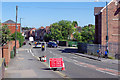
Coleshill Road, Atherstone
No motorist wants to find themselves approaching this - a 4-way temporary traffic light control just as it turns red. Oddly, there is no obvious sign of any roadworks - and how is the blue car turning into Westwood Road from the opposite direction?
Image: © Stephen McKay
Taken: 9 Sep 2020
0.03 miles
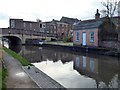
2
Advertisements by the Coventry Canal
It is not unusual for pubs and other businesses to advertise themselves to canal boaters - it all adds to the interest, but beware of any establishment claiming to be ten minutes away (reckon on at least double that!) This is a particularly curious collection by bridge 41 in Atherstone. Anyone expecting a warm welcome at the Barge and Bridge will be disappointed - the pub closed in 2015 and has since been demolished. And who exactly is selling Calor Gas?
Image: © Stephen McKay
Taken: 9 Sep 2020
0.04 miles
3
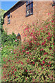
Fuchsia by the towpath
A burst of colour between the towpath and a canalside building close to bridge 41.
Image: © Stephen McKay
Taken: 9 Sep 2020
0.04 miles
4
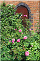
Roses by the towpath
Pink roses grow between the towpath and a canalside building close to bridge 41.
Image: © Stephen McKay
Taken: 9 Sep 2020
0.04 miles
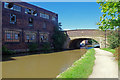
5
Coventry Canal in Atherstone, Warwickshire
This is the Coventry Canal in Atherstone, south-east of Coleshill Road Bridge, No 41.
Image: © Roger D Kidd
Taken: 19 Aug 2013
0.04 miles
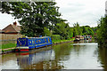
6

Canal boat Chelmer, Coventry Canal, Atherstone
Image: © Ian S
Taken: 6 Jan 2022
0.04 miles
7
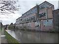
Former hat factory
The derelict factory of Wilson & Stafford Ltd. The Coventry Canal is in the foreground.
Image: © Chris Allen
Taken: 10 Nov 2018
0.05 miles
8

Coventry Canal towards Coleshill Road, Bridge #41
Image: © Ian S
Taken: 6 Jan 2022
0.05 miles
9
Coventry Canal, Atherstone
On the other side of bridge 41 is Atherstone Top Lock, the first of a flight of 11. On the left is part of a derelict factory, the former premises of Wilson & Stafford Ltd, hat makers. Atherstone once had two main industries: coal mining and hat making, both of which have now completely disappeared. Wilson & Stafford was in fact the last manufacturer of felt hats, not only in Atherstone but in the whole of Great Britain. The company went into liquidation in 1999; it is perhaps surprising that it lasted that long given that hats had long since ceased to be essential fashion items for both men and women. Although there were plans to demolish the building in 2008, it remains standing in 2020.
Image: © Stephen McKay
Taken: 9 Sep 2020
0.05 miles
10
Minion's Wharf
At the top of the Atherstone flight on the Coventry Canal. The building on the right was seen to be in a coal yard in an earlier shot. The factory in the background on Coleshill Road is the derelict Wilson & Stafford Ltd hat factory.
Image: © Chris Allen
Taken: 10 Nov 2018
0.05 miles