IMAGES TAKEN NEAR TO
Stratford Avenue, ATHERSTONE, CV9 2AW
Introduction
This page details the photographs taken nearby to Stratford Avenue, CV9 2AW by members of the Geograph project.
The Geograph project started in 2005 with the aim of publishing, organising and preserving representative images for every square kilometre of Great Britain, Ireland and the Isle of Man.

There are currently over 7.5m images from over14,400 individuals and you can help contribute to the project by visiting https://www.geograph.org.uk
Image Map
Images are licensed for reuse under creativecommons.org/licenses/by-sa/2.0
Notes
- Clicking on the map will re-center to the selected point.
- The higher the marker number, the further away the image location is from the centre of the postcode.
Image Listing (91 Images Found)
Images are licensed for reuse under creativecommons.org/licenses/by-sa/2.0
Image
Details
Distance
1
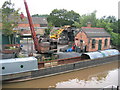
Rothen's Wharf, Atherstone
At one time coal was delivered to this wharf from the local collieries by narrowboat for delivery by road around the Atherstone area. These days however the wharf is still used for coal deliveries, however the coal arrives by road and is transported by narrowboat to users along the canal.
Image: © David Stowell
Taken: 29 Jul 2006
0.13 miles
2
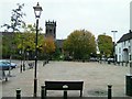
St Mary's Church Atherstone
Market Sq and Parish church
Image: © Andy and Hilary
Taken: Unknown
0.14 miles
3
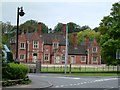
Railway Station
Atherstone Railway station which sadly has been vandalised.
Image: © Andy and Hilary
Taken: 10 Oct 2004
0.14 miles
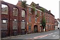
4
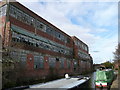
Wilson & Stafford Hat Factory
The last hat factory in Atherstone, closed several years ago and due to be converted into flats commencing in 2008.
Image: © Ian Filmer
Taken: 11 Nov 2007
0.14 miles
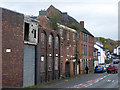
5
Atherstone-Derelict Factory
Former Hatmakers on Coleshill Road.Closed since 1999.
Image: © Ian Rob
Taken: 29 Aug 2019
0.15 miles
6
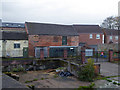
Ramshackle industrial buildings by Minion's Wharf
Alongside the Coventry Canal at Atherstone and photographed from bridge No. 41 over the canal.
Image: © Chris Allen
Taken: 10 Nov 2018
0.15 miles
7
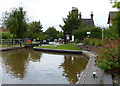
Atherstone Top Lock No 1 on the Coventry Canal
Image: © Mat Fascione
Taken: 13 Sep 2015
0.16 miles
8
Former hat factory, Atherstone
The derelict factory of Wilson & Stafford Ltd. Just beyond is the appropriately named public house - The Maid of The Mill. Perhaps it would have been a nice port of call for a pint but instead I went to a very interesting pub in the town centre.
Image: © Chris Allen
Taken: 10 Nov 2018
0.16 miles
9
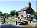
Atherstone Top Lock, Coventry Canal, Warwickshire
This is the first lock of eleven lowering the water level by eighty feet (24.4 metres) over about two miles (three kilometres). As the canal company had run out of money by 1771 when it reached Atherstone on its course from Coventry, these locks and the rest of the route were constructed later, eventually arriving at Fazeley in 1790.
Image: © Roger D Kidd
Taken: 10 Jun 2008
0.16 miles
10
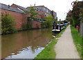
Disused factories along the Coventry Canal
In the Warwickshire town of Atherstone.
Image: © Mat Fascione
Taken: 13 Sep 2015
0.16 miles