IMAGES TAKEN NEAR TO
Penny Hapenny Court, ATHERSTONE, CV9 2AA
Introduction
This page details the photographs taken nearby to Penny Hapenny Court, CV9 2AA by members of the Geograph project.
The Geograph project started in 2005 with the aim of publishing, organising and preserving representative images for every square kilometre of Great Britain, Ireland and the Isle of Man.

There are currently over 7.5m images from over14,400 individuals and you can help contribute to the project by visiting https://www.geograph.org.uk
Image Map
Images are licensed for reuse under creativecommons.org/licenses/by-sa/2.0
Notes
- Clicking on the map will re-center to the selected point.
- The higher the marker number, the further away the image location is from the centre of the postcode.
Image Listing (172 Images Found)
Images are licensed for reuse under creativecommons.org/licenses/by-sa/2.0
Image
Details
Distance
1
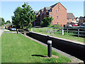
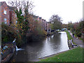
Atherstone Locks No 2, Coventry Canal, Warwickshire
This is second lock of eleven altering the water level by eighty feet (24.4 metres) over about two miles (three kilometres).
As the canal company had run out of money by 1771 when it reached Atherstone on its course from Coventry, these locks and the rest of the route were constructed later, eventually arriving at Fazeley in 1790.
Image: © Roger D Kidd
Taken: 10 Jun 2008
0.02 miles
2
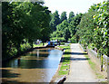
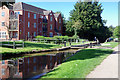
The Coventry Canal at Atherstone Locks, Warwickshire
Looking along the pound towards Lock No 2 from the top lock.
This is the first lock of eleven lowering the water level by eighty feet (24.4 metres) over about two miles (three kilometres). As the canal company had run out of money by 1771 when it reached Atherstone on its course from Coventry, these locks and the rest of the route were constructed later, eventually arriving at Fazeley in 1790.
Image: © Roger D Kidd
Taken: 10 Jun 2008
0.02 miles
3
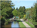
Atherstone Locks No 2 in Warwickshire
This is the Coventry Canal, looking north-west towards Lock No 2, from Top Lock No 1.
The Atherstone flight of eleven locks lowers (or raises) the water level by eighty feet (24.4 metres) over about two miles (three kilometres). As the canal company had run out of money by 1771 when it reached Atherstone on its course from Coventry, these locks and the rest of the route were constructed later, eventually arriving at Fazeley in 1790.
Image: © Roger Kidd
Taken: 22 Sep 2016
0.02 miles
4
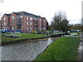
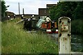
Lock No. 2 Atherstone flight
On the Coventry Canal.
Image: © Chris Allen
Taken: 10 Nov 2018
0.03 miles
5
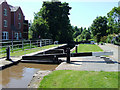
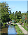
Atherstone Lock 2, Coventry Canal
Overlooked by a modern apartment block, this is the second lock (going down) of the flight of 11.
Image: © Stephen McKay
Taken: 9 Sep 2020
0.03 miles
6
On the Atherstone flight ? 1978
The ground paddle for Lock No.2 carries the date 1916.
The lock is Listed Grade II.
Image: © Alan Murray-Rust
Taken: 10 Jun 1978
0.03 miles
7
Atherstone Locks No 2, Coventry Canal, Warwickshire
This is the second lock of eleven lowering the water level by eighty feet (24.4 metres) over about two miles (three kilometres). As the canal company had run out of money by 1771 when it reached Atherstone on its course from Coventry, these locks and the rest of the route were constructed later, eventually arriving at Fazeley in 1790.
Image: © Roger D Kidd
Taken: 10 Jun 2008
0.03 miles
8
Atherstone Lock No 2 on the Coventry Canal
Image: © Mat Fascione
Taken: 13 Sep 2015
0.03 miles
9
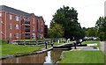
Coventry Canal, Atherstone
I am by the tail of the top lock and looking down the flight. Note the fake heron by the water issuing from the bypass. Lock No. 2 is seen in the distance.
Image: © Chris Allen
Taken: 10 Nov 2018
0.03 miles
10
Atherstone Locks No 2 in Warwickshire
This is the Coventry Canal, looking north-west towards Lock No 2, from Top Lock No 1.
The Atherstone flight of eleven locks lowers (or raises) the water level by eighty feet (24.4 metres) over about two miles (three kilometres). As the canal company had run out of money by 1771 when it reached Atherstone on its course from Coventry, these locks and the rest of the route were constructed later, eventually arriving at Fazeley in 1790.
Image: © Roger Kidd
Taken: 22 Sep 2016
0.03 miles