IMAGES TAKEN NEAR TO
Cadman Close, ATHERSTONE, CV9 1RL
Introduction
This page details the photographs taken nearby to Cadman Close, CV9 1RL by members of the Geograph project.
The Geograph project started in 2005 with the aim of publishing, organising and preserving representative images for every square kilometre of Great Britain, Ireland and the Isle of Man.

There are currently over 7.5m images from over14,400 individuals and you can help contribute to the project by visiting https://www.geograph.org.uk
Image Map
Images are licensed for reuse under creativecommons.org/licenses/by-sa/2.0
Notes
- Clicking on the map will re-center to the selected point.
- The higher the marker number, the further away the image location is from the centre of the postcode.
Image Listing (17 Images Found)
Images are licensed for reuse under creativecommons.org/licenses/by-sa/2.0
Image
Details
Distance
1
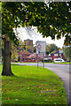
Mancetter Road
The B4111 passes round the edge of Mancetter village and is seen here with St Peter's Church in the background. As the name indicates, Mancetter has Roman origins as the site of a fort on Watling Street called Manduessedum. In modern times Mancetter has been pretty much absorbed by Atherstone.
Image: © Stephen McKay
Taken: 9 Nov 2022
0.14 miles
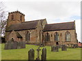
3
Mancetter Church
The parish church is a dominant feature in Mancetter.
Image: © Peter Mackenzie
Taken: 28 Jan 2017
0.19 miles
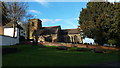
4
Mancetter Church
St Peter's Church dates mainly from the 13th century although it has 12th century origins. The tower is 14th century with 15th century upper parts. Restoration was carried out in 1876, 1911 and 1930. The building is grade I listed.
Image: © Stephen McKay
Taken: 9 Nov 2022
0.19 miles
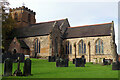
5
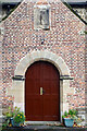
Mancetter Church - south porch
St Peter's Church mainly dates from the 13th-14th century, but this south porch is Georgian.
Image: © Stephen McKay
Taken: 9 Nov 2022
0.19 miles
6
The Blue Boar Inn, Mancetter
At the corner of Watling Street and Mancetter Road.
Image: © Mat Fascione
Taken: 9 Feb 2008
0.20 miles
8
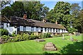
Mancetter Almshouses
This row of almshouses, overlooking St Peter's churchyard, were built in 1728, paid for by James Cramer, a local man who had made his fortune as a goldsmith in London. They housed six men over the age of 60 who were required to attend church on Sundays and holy days if they were well enough. The almshouses were renovated in 1990-91.
Image: © Stephen McKay
Taken: 9 Nov 2022
0.21 miles
9
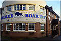
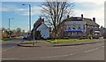
The Blue Boar Inn, Atherstone
The Blue Boar Inn was built in the 1940s and the architecture is very much of its time. In those days - and for many years afterwards - it faced on to the A5, so can be considered a mid 20th century roadhouse. However, in 1997 it was taken over by the Sperrin Brothers and is a sister pub to the Lord Nelson Inn at Ansley. Today, as well as a bar and restaurant it offers six en-suite rooms.
Image: © Stephen McKay
Taken: 18 Nov 2022
0.21 miles
10

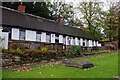
Gramer Cottages, Mancetter
The board on the front of these almshouses names them as 'Gramer Cottages' although the man whose endowment paid for them is called James Cramer elsewhere. They were built in 1822 to supplement the older almshouses on the opposite side of the road by the churchyard, providing accommodation for five poor men. In the official grade II listing there is reference to a cast iron open verandah which can be seen in this 2004 photograph: Image For whatever reason the verandah has since been removed.
Image: © Stephen McKay
Taken: 9 Nov 2022
0.21 miles