IMAGES TAKEN NEAR TO
Adrians Close, ATHERSTONE, CV9 1RH
Introduction
This page details the photographs taken nearby to Adrians Close, CV9 1RH by members of the Geograph project.
The Geograph project started in 2005 with the aim of publishing, organising and preserving representative images for every square kilometre of Great Britain, Ireland and the Isle of Man.

There are currently over 7.5m images from over14,400 individuals and you can help contribute to the project by visiting https://www.geograph.org.uk
Image Map
Images are licensed for reuse under creativecommons.org/licenses/by-sa/2.0
Notes
- Clicking on the map will re-center to the selected point.
- The higher the marker number, the further away the image location is from the centre of the postcode.
Image Listing (5 Images Found)
Images are licensed for reuse under creativecommons.org/licenses/by-sa/2.0
Image
Details
Distance
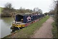
1
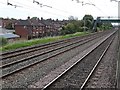
View from a Rugby-Crewe train - Footbridge near Manor Road, Mancetter
The Trent Valley railway line is four tracks wide at this point.
Image: © Nigel Thompson
Taken: 23 Jun 2018
0.19 miles
2
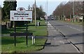
Welcome to Atherstone
Along the B4116 Witherley road.
Image: © Mat Fascione
Taken: 9 Feb 2008
0.24 miles
3
The Blue Boar Inn, Mancetter
At the corner of Watling Street and Mancetter Road.
Image: © Mat Fascione
Taken: 9 Feb 2008
0.24 miles
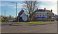
4
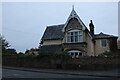
Old house on Witherley Road, Atherstone
You either love or hate this sort of Victorian European pastiche style, to me it looks like the Munsters should live here.
Image: © David Howard
Taken: 18 Oct 2020
0.25 miles