IMAGES TAKEN NEAR TO
Nuneaton Road, ATHERSTONE, CV9 1RF
Introduction
This page details the photographs taken nearby to Nuneaton Road, CV9 1RF by members of the Geograph project.
The Geograph project started in 2005 with the aim of publishing, organising and preserving representative images for every square kilometre of Great Britain, Ireland and the Isle of Man.

There are currently over 7.5m images from over14,400 individuals and you can help contribute to the project by visiting https://www.geograph.org.uk
Image Map
Images are licensed for reuse under creativecommons.org/licenses/by-sa/2.0
Notes
- Clicking on the map will re-center to the selected point.
- The higher the marker number, the further away the image location is from the centre of the postcode.
Image Listing (16 Images Found)
Images are licensed for reuse under creativecommons.org/licenses/by-sa/2.0
Image
Details
Distance
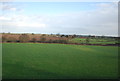
3
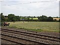
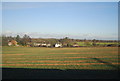
View from a Rugby-Crewe train - Tractor at work
The Trent Valley railway line is four tracks wide at this point.
Image: © Nigel Thompson
Taken: 23 Jun 2018
0.13 miles
6
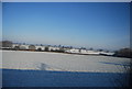
Snowscene between the West Coast Main Line and the B4111 near Dobbies World
The B4111 is behind the hedge running across the photo in the middle distance.
Image: © N Chadwick
Taken: 19 Dec 2010
0.18 miles
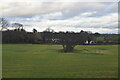
10
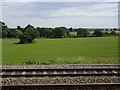
View from a Rugby-Crewe train - Fields near Mancetter
Image: © Nigel Thompson
Taken: 23 Jun 2018
0.21 miles