IMAGES TAKEN NEAR TO
Manor Road, ATHERSTONE, CV9 1QR
Introduction
This page details the photographs taken nearby to Manor Road, CV9 1QR by members of the Geograph project.
The Geograph project started in 2005 with the aim of publishing, organising and preserving representative images for every square kilometre of Great Britain, Ireland and the Isle of Man.

There are currently over 7.5m images from over14,400 individuals and you can help contribute to the project by visiting https://www.geograph.org.uk
Image Map
Images are licensed for reuse under creativecommons.org/licenses/by-sa/2.0
Notes
- Clicking on the map will re-center to the selected point.
- The higher the marker number, the further away the image location is from the centre of the postcode.
Image Listing (19 Images Found)
Images are licensed for reuse under creativecommons.org/licenses/by-sa/2.0
Image
Details
Distance
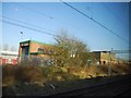
1
View from a Rugby-Crewe train - Footbridge near Manor Road, Mancetter
The Trent Valley railway line is four tracks wide at this point.
Image: © Nigel Thompson
Taken: 23 Jun 2018
0.04 miles
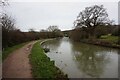
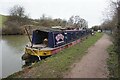
3
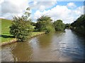
Coventry Canal: Reach near Rawn Hill
The canal winds its way around the contours of Rawn Hill, to the left, here.
Image: © Nigel Cox
Taken: 11 Sep 2012
0.16 miles
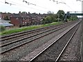
8
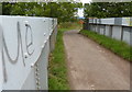
Bridge and track across the West Coast Main Line
This track leads to the Manor Road Industrial Estate in Atherstone.
Image: © Mat Fascione
Taken: 13 Sep 2015
0.22 miles
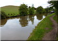
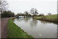
9
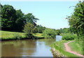
The Coventry Canal near Mancetter, Warwickshire
This rural section of the canal bypassing Mancetter was the last that James Brindley constructed before being sacked by the company, which had run out of money on reaching Atherstone (about another half a mile ahead) in 1771.
Image: © Roger D Kidd
Taken: 10 Jun 2008
0.22 miles