IMAGES TAKEN NEAR TO
Priory Walk, ATHERSTONE, CV9 1QB
Introduction
This page details the photographs taken nearby to Priory Walk, CV9 1QB by members of the Geograph project.
The Geograph project started in 2005 with the aim of publishing, organising and preserving representative images for every square kilometre of Great Britain, Ireland and the Isle of Man.

There are currently over 7.5m images from over14,400 individuals and you can help contribute to the project by visiting https://www.geograph.org.uk
Image Map (Loading...)


Getting Data...Please wait
Leaflet Map data © OpenStreetMap
Images are licensed for reuse under creativecommons.org/licenses/by-sa/2.0
Notes
- Clicking on the map will re-center to the selected point.
- The higher the marker number, the further away the image location is from the centre of the postcode.
Image Listing (5 Images Found)
Images are licensed for reuse under creativecommons.org/licenses/by-sa/2.0
Image
Details
Distance
1
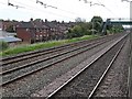
View from a Rugby-Crewe train - Footbridge near Manor Road, Mancetter
The Trent Valley railway line is four tracks wide at this point.
Image: © Nigel Thompson
Taken: 23 Jun 2018
0.16 miles
3
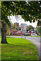
Mancetter Road
The B4111 passes round the edge of Mancetter village and is seen here with St Peter's Church in the background. As the name indicates, Mancetter has Roman origins as the site of a fort on Watling Street called Manduessedum. In modern times Mancetter has been pretty much absorbed by Atherstone.
Image: © Stephen McKay
Taken: 9 Nov 2022
0.24 miles
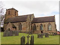
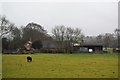
5
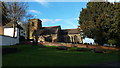
Mancetter Church
The parish church is a dominant feature in Mancetter.
Image: © Peter Mackenzie
Taken: 28 Jan 2017
0.25 miles