IMAGES TAKEN NEAR TO
St. Marys Road, ATHERSTONE, CV9 1JR
Introduction
This page details the photographs taken nearby to St. Marys Road, CV9 1JR by members of the Geograph project.
The Geograph project started in 2005 with the aim of publishing, organising and preserving representative images for every square kilometre of Great Britain, Ireland and the Isle of Man.

There are currently over 7.5m images from over14,400 individuals and you can help contribute to the project by visiting https://www.geograph.org.uk
Image Map
Images are licensed for reuse under creativecommons.org/licenses/by-sa/2.0
Notes
- Clicking on the map will re-center to the selected point.
- The higher the marker number, the further away the image location is from the centre of the postcode.
Image Listing (70 Images Found)
Images are licensed for reuse under creativecommons.org/licenses/by-sa/2.0
Image
Details
Distance
1
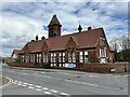
Atherstone Girls' and Infants' School, Ratcliffe Road
Erected at a cost of £3,600 and opened on 31 December 1883. Architect William Millican of Leicester.
Image: © Andrew Abbott
Taken: 1 May 2023
0.09 miles
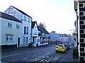
2
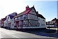
Atherstone-The Old Swan
On the corner of Long Street and Welcome Street.
Image: © Ian Rob
Taken: 29 Aug 2019
0.11 miles
3
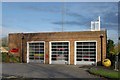
Atherstone fire station
Atherstone fire station, Kings Avenue, Atherstone, Warwickshire
Image: © Kevin Hale
Taken: 25 Nov 2006
0.11 miles
5
Long Street looking west
A misty day looking down Long Street, with the timbered framed Old Swan pub on the left, and further along the pale pink coloured building is the Conservative Club. Image
Image: © P L Chadwick
Taken: 28 Dec 2009
0.11 miles
6
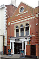
Albert Hall, Atherstone
The Albert Hall on Long Street in the centre of Atherstone was built in 1876 as a mission hall and could accommodate 500 people. It is now used as a gym.
Image: © Stephen McKay
Taken: 9 Sep 2020
0.12 miles
7
Long Street looking east from junction with Woolpack Way
The mini-roundabout marks the junction of Long Street and Woolpack Way. This part of Long Street is quieter than the western section, as there are not many shops here. There are however several pubs, plus the Conservative Club on the corner. Image
In the far distance, on the right, is one of Atherstone's best known pubs, the black & white timber framed Old Swan. Image
Image: © P L Chadwick
Taken: 28 Dec 2009
0.12 miles
8
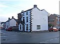
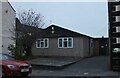
Old house, North Street
This house is believed to date from the early 19th century.
Image: © P L Chadwick
Taken: 28 Dec 2009
0.12 miles
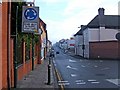
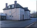
9
Conservative Club, Long Street
Image: © P L Chadwick
Taken: 28 Dec 2009
0.13 miles
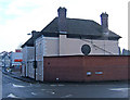
10
Conservative Club, Long Street
Licensed club on the corner of Long Street and Woolpack Way. Can accommodate up to 350 members. The building itself dates originally from the late 17th century, but was heavily altered and added to in the 19th century.Image; Image
Image: © P L Chadwick
Taken: 28 Dec 2009
0.13 miles