IMAGES TAKEN NEAR TO
Grove Road, ATHERSTONE, CV9 1DJ
Introduction
This page details the photographs taken nearby to Grove Road, CV9 1DJ by members of the Geograph project.
The Geograph project started in 2005 with the aim of publishing, organising and preserving representative images for every square kilometre of Great Britain, Ireland and the Isle of Man.

There are currently over 7.5m images from over14,400 individuals and you can help contribute to the project by visiting https://www.geograph.org.uk
Image Map
Images are licensed for reuse under creativecommons.org/licenses/by-sa/2.0
Notes
- Clicking on the map will re-center to the selected point.
- The higher the marker number, the further away the image location is from the centre of the postcode.
Image Listing (124 Images Found)
Images are licensed for reuse under creativecommons.org/licenses/by-sa/2.0
Image
Details
Distance
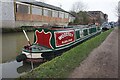
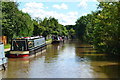
5

Canal boat Black Pepper, Coventry Canal, Atherstone
Image: © Ian S
Taken: 6 Jan 2022
0.12 miles
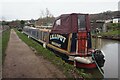
7
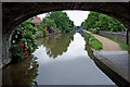
Coventry Canal in Atherstone, Warwickshire
Looking north-west through the arch of Taverners Bridge, No 40.
Image: © Roger Kidd
Taken: 18 Jun 2010
0.12 miles
8
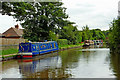
Coventry Canal in Atherstone, Warwickshire
This is the Coventry Canal in Atherstone, south-east of Coleshill Road Bridge, No 41.
Image: © Roger D Kidd
Taken: 19 Aug 2013
0.13 miles

10
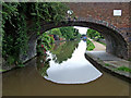
Coventry Canal in Atherstone, Warwickshire
Looking north-west through the arch of Taverners Bridge, No 40.
Image: © Roger Kidd
Taken: 18 Jun 2010
0.13 miles