IMAGES TAKEN NEAR TO
Coleshill Road, ATHERSTONE, CV9 1BT
Introduction
This page details the photographs taken nearby to Coleshill Road, CV9 1BT by members of the Geograph project.
The Geograph project started in 2005 with the aim of publishing, organising and preserving representative images for every square kilometre of Great Britain, Ireland and the Isle of Man.

There are currently over 7.5m images from over14,400 individuals and you can help contribute to the project by visiting https://www.geograph.org.uk
Image Map
Images are licensed for reuse under creativecommons.org/licenses/by-sa/2.0
Notes
- Clicking on the map will re-center to the selected point.
- The higher the marker number, the further away the image location is from the centre of the postcode.
Image Listing (196 Images Found)
Images are licensed for reuse under creativecommons.org/licenses/by-sa/2.0
Image
Details
Distance
1
Trinity Church, Atherstone
Grade II listed. Listing number 1365147.
Image: © Andrew Abbott
Taken: 1 May 2023
0.04 miles
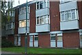
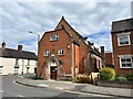
2
68 Coleshill Road, Atherstone
Grade II listed. Listing number 1299864. The house was constructed sometime between 1771 and 1790, as the house and offices for the wharfinger at adjacent Atherstone Wharf, a coal wharf at what was then the termination of the Coventry Canal. The wharf was constructed in 1771, and the house appears to date from this period or shortly afterwards; it appears on the earliest map of the canal, circa 1790, as Queen Anne House, and was named as the house of Richard Pipes. The earliest phase, which was T-shaped on plan, was extended by the addition of a single-storey, one-bay extension to the front of the building in the mid-C19, and a single-storey extension to the south was added at roughly the same period. The rear was extended by the addition of a relatively narrow outshut in the later C19, and a further addition was made to the rear in the early C20. The building continued in use as a wharfinger's house throughout the C19
Image: © Andrew Abbott
Taken: 1 May 2023
0.05 miles
3
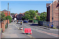
Coleshill Road, Atherstone
No motorist wants to find themselves approaching this - a 4-way temporary traffic light control just as it turns red. Oddly, there is no obvious sign of any roadworks - and how is the blue car turning into Westwood Road from the opposite direction?
Image: © Stephen McKay
Taken: 9 Sep 2020
0.06 miles
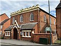
4
Former Independent Chapel, Coleshill Street West, Atherstone
Opened on 27 March 1856.
Image: © Andrew Abbott
Taken: 1 May 2023
0.07 miles
5
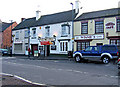
The White Lion, Station Street
This has been a pub certainly since around 1817, possibly earlier. They are fond of lions in this area. Atherstone has this White Lion, plus the Red Lion Hotel and nearby at Witherley is the Blue Lion Inn.
Next door to The White Lion, on the left, is Atherstone House, a Chinese Take Away. On the other side is Winnie's Cafe.
Image: © P L Chadwick
Taken: 28 Dec 2009
0.07 miles
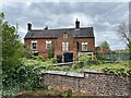
6
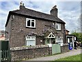
Top Lock Cottage, Atherstone
On the Coventry Canal.
Image: © Andrew Abbott
Taken: 1 May 2023
0.08 miles
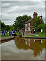
7
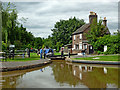
Atherstone Top Lock and cottage, Warwickshire
Atherstone Top Lock, No 1.
On the Coventry Canal, the Atherstone flight of eleven locks lowers (or raises) the water level by eighty feet (24.4 metres) over about two miles (three kilometres). As the canal company had run out of money by 1771 when it reached Atherstone on its course from Coventry, these locks and the rest of the route were constructed later, eventually arriving at Fazeley in 1790.
Jo urner writes:
Image: © Roger D Kidd
Taken: 19 Aug 2013
0.08 miles
8
Atherstone Top Lock and cottage, Warwickshire
Atherstone Top Lock, No 1.
On the Coventry Canal, the Atherstone flight of eleven locks lowers (or raises) the water level by eighty feet (24.4 metres) over about two miles (three kilometres). As the canal company had run out of money by 1771 when it reached Atherstone on its course from Coventry, these locks and the rest of the route were constructed later, eventually arriving at Fazeley in 1790.
Image: © Roger D Kidd
Taken: 19 Aug 2013
0.08 miles
9
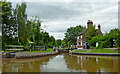
Atherstone Top Lock in Warwickshire
Atherstone Top Lock, No 1.
On the Coventry Canal, the Atherstone flight of eleven locks lowers (or raises) the water level by eighty feet (24.4 metres) over about two miles (three kilometres). As the canal company had run out of money by 1771 when it reached Atherstone on its course from Coventry, these locks and the rest of the route were constructed later, eventually arriving at Fazeley in 1790.
Image: © Roger D Kidd
Taken: 19 Aug 2013
0.08 miles