IMAGES TAKEN NEAR TO
Long Street, ATHERSTONE, CV9 1BJ
Introduction
This page details the photographs taken nearby to Long Street, CV9 1BJ by members of the Geograph project.
The Geograph project started in 2005 with the aim of publishing, organising and preserving representative images for every square kilometre of Great Britain, Ireland and the Isle of Man.

There are currently over 7.5m images from over14,400 individuals and you can help contribute to the project by visiting https://www.geograph.org.uk
Image Map
Images are licensed for reuse under creativecommons.org/licenses/by-sa/2.0
Notes
- Clicking on the map will re-center to the selected point.
- The higher the marker number, the further away the image location is from the centre of the postcode.
Image Listing (182 Images Found)
Images are licensed for reuse under creativecommons.org/licenses/by-sa/2.0
Image
Details
Distance
1
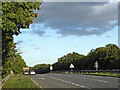
A5 dual carriageway in Atherstone, Warwickshire
Looking east and bypassing Atherstone town centre, replacing Watling Street. The road crosses the railway here.
Image: © Roger Kidd
Taken: 25 Sep 2016
0.04 miles
2
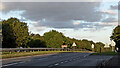
A5 dual carriageway in Atherstone, Warwickshire
Looking east in evening sunlight, and bypassing Atherstone town centre, replacing Watling Street. The road crosses the railway here.
Image: © Roger Kidd
Taken: 25 Sep 2016
0.04 miles
3
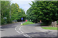
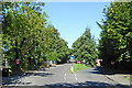
A5 approach, Atherstone
At the western end of Atherstone town centre this road approaches its junction with the modern A5 at a grade separated junction.
Image: © Stephen McKay
Taken: 9 Sep 2020
0.05 miles
4
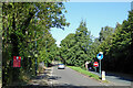
The old A5 in Atherstone, Warwickshire
Looking north-west towards the newer A5 Atherstone By-pass, which was opened in 1963. This "old" A5 is an earlier twentieth century* necessary Watling Street diversion to avoid the low bridge here: https://www.geograph.org.uk/photo/7426596.
* can a local historian let us know the date of this earlier road?
Image: © Roger Kidd
Taken: 22 Sep 2016
0.05 miles
5
The old A5 in Atherstone, Warwickshire
Looking north-west towards the newer A5 Atherstone Bypass, which was opened in 1963. This "old" A5 is an earlier twentieth century* necessary Watling Street diversion to avoid the low bridge here: https://www.geograph.org.uk/photo/7426596.
* can a local historian let us know the date of this earlier road?
Image: © Roger Kidd
Taken: 22 Sep 2016
0.05 miles
6
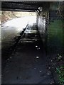
Pavement lights under low bridge
Set into the pavement under this low railway bridge are a set of bright white uplights. There also appears to be larger downward pointing lights above them but these were not illuminated.
Image: © Rob Farrow
Taken: 6 Dec 2009
0.06 miles
7
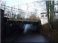
Atherstone - Low railway bridge
The same low bridge (6'9") as seen in Image], but from the opposite side, looking westwards. Note the little lights set into the pavement on the lefthand side. These can be seen more clearly in Image]
Image: © Rob Farrow
Taken: 6 Dec 2009
0.07 miles
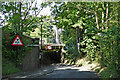
8
Low bridge on Old Watling Street
This low railway bridge is on the western side of Atherstone and carries the West Coast Main Line across the Old Watling Street. The opposite side view can be seen here Image] and a close view here Image]
Image: © Rob Farrow
Taken: 6 Dec 2009
0.07 miles
9
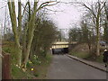
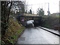
Old Watling Street
Looking towards the bridge that carries the Trent Valley Railway.
Image: © Tim Glover
Taken: 20 Mar 2003
0.07 miles
10
Old Watling Street in Atherstone, Warwickshire
Looking north-west from near the junction with Long Street. The West Coast Main Line (Trent Valley) railway crosses the original Roman road.
Image: © Roger Kidd
Taken: 22 Sep 2016
0.07 miles