IMAGES TAKEN NEAR TO
Charlotte Way, ATHERSTONE, CV9 1AW
Introduction
This page details the photographs taken nearby to Charlotte Way, CV9 1AW by members of the Geograph project.
The Geograph project started in 2005 with the aim of publishing, organising and preserving representative images for every square kilometre of Great Britain, Ireland and the Isle of Man.

There are currently over 7.5m images from over14,400 individuals and you can help contribute to the project by visiting https://www.geograph.org.uk
Image Map
Images are licensed for reuse under creativecommons.org/licenses/by-sa/2.0
Notes
- Clicking on the map will re-center to the selected point.
- The higher the marker number, the further away the image location is from the centre of the postcode.
Image Listing (17 Images Found)
Images are licensed for reuse under creativecommons.org/licenses/by-sa/2.0
Image
Details
Distance
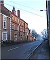
1
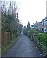
Church Walk
This lengthy lane would long ago have been the route for Atherstone people to get to the church at nearby Mancetter. The church there was for several hundred years the parish church for both places.
Image: © P L Chadwick
Taken: 28 Dec 2009
0.11 miles
2
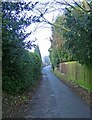
Church Walk
This used to provide the connection between the Parish Church at nearby Mancetter and Long Street, Atherstone's main street. Image
Image: © P L Chadwick
Taken: 28 Dec 2009
0.11 miles
3
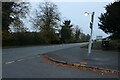
Witherley Road at the corner of Convent Lane
Image: © David Howard
Taken: 18 Oct 2020
0.13 miles
4
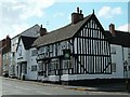
Old Swan
The old swan inn on long street Atherstone.
Image: © Andy and Hilary
Taken: 8 May 2005
0.14 miles
5
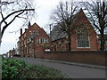
Queen Elizabeth School, Atherstone.
Queen Elizabeth Grammar School was established, in Atherstone, in 1573. It became a Comprehensive school in 1976 and was recently given the status of 'Sports College'.
Image: © Roy William Shakespeare
Taken: 15 Mar 2007
0.18 miles
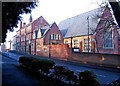
6
Queen Elizabeth School & Sports College
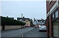
Queen Elizabeth School & Sports College was founded in Atherstone in 1573, but not on this site. It became a comprehensive school in 1976 and subsequently was given the status of a sports college. The road on the left is Long Street, and the one going off to the right is North Street.
Atherstone was experiencing a slight mist when this and other photographs here were taken on a dull December day, so this has affected the clarity and contrast to some degree.
Image: © P L Chadwick
Taken: 28 Dec 2009
0.19 miles
7
Long Street and the Queen Elizabeth School & Sports College
The side of the school dominates this final section of Long Street. It was quite a misty December day when this photograph was taken. Image
Image: © P L Chadwick
Taken: 28 Dec 2009
0.20 miles
8
Queen Elizabeth School & Sports College
Another view:- Image
Image: © P L Chadwick
Taken: 28 Dec 2009
0.20 miles
9
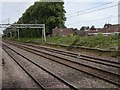
View from a Rugby-Crewe train - Houses and trees, Atherstone
The Trent Valley railway line is four tracks wide at this point.
Image: © Nigel Thompson
Taken: 23 Jun 2018
0.20 miles