IMAGES TAKEN NEAR TO
School Street, COVENTRY, CV8 3FY
Introduction
This page details the photographs taken nearby to School Street, CV8 3FY by members of the Geograph project.
The Geograph project started in 2005 with the aim of publishing, organising and preserving representative images for every square kilometre of Great Britain, Ireland and the Isle of Man.

There are currently over 7.5m images from over14,400 individuals and you can help contribute to the project by visiting https://www.geograph.org.uk
Image Map (Loading...)


Getting Data...Please wait
Leaflet Map data © OpenStreetMap
Images are licensed for reuse under creativecommons.org/licenses/by-sa/2.0
Notes
- Clicking on the map will re-center to the selected point.
- The higher the marker number, the further away the image location is from the centre of the postcode.
Image Listing (5 Images Found)
Images are licensed for reuse under creativecommons.org/licenses/by-sa/2.0
Image
Details
Distance
3
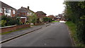
Housing in Wolston
Semi-detached houses typical of this delightful village.
Image: © Peter Mackenzie
Taken: 21 Oct 2017
0.10 miles
4
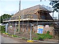
Undergoing conversion
The farm buildings at Priory Farm are being converted to residential use.
Image: © Michael Dibb
Taken: 21 Jul 2019
0.17 miles
5
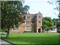
The Priory
The Priory is a very fine 16th century house incorporating parts of an earlier 14th or 15th century timber framed building. This earlier building was part of the Benedictine Wolston Priory established in the late 11th or early 12th century. There are many original internal features. The house is now used as offices. Listed, grade II*, with details at: https://historicengland.org.uk/listing/the-list/list-entry/1365082
Image: © Michael Dibb
Taken: 21 Jul 2019
0.21 miles