IMAGES TAKEN NEAR TO
Trinity Close, COVENTRY, CV8 3FA
Introduction
This page details the photographs taken nearby to Trinity Close, CV8 3FA by members of the Geograph project.
The Geograph project started in 2005 with the aim of publishing, organising and preserving representative images for every square kilometre of Great Britain, Ireland and the Isle of Man.

There are currently over 7.5m images from over14,400 individuals and you can help contribute to the project by visiting https://www.geograph.org.uk
Image Map (Loading...)


Getting Data...Please wait
Leaflet Map data © OpenStreetMap
Images are licensed for reuse under creativecommons.org/licenses/by-sa/2.0
Notes
- Clicking on the map will re-center to the selected point.
- The higher the marker number, the further away the image location is from the centre of the postcode.
Image Listing (36 Images Found)
Images are licensed for reuse under creativecommons.org/licenses/by-sa/2.0
Image
Details
Distance
1
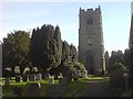
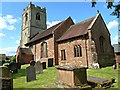
Ryton-Saint Leonards Church
The tower and graveyard.
Image: © Ian Rob
Taken: 5 Mar 2008
0.02 miles
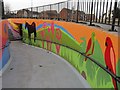
5
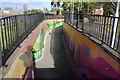
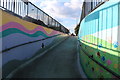
Ryton Subway
This has been covered from end to end by a local artist.
Image: © David Howard
Taken: 4 May 2019
0.03 miles
6

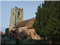
Ryton-Saint Leonard's Church
Parts of this Norman Church date from 1080.
Image: © Ian Rob
Taken: 5 Mar 2008
0.03 miles
8
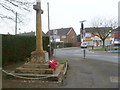
Ryton-on-Dunsmore, war memorial
At the corner of High Street and London Road.
Image: © Mike Faherty
Taken: 4 Feb 2012
0.04 miles
9
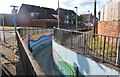
Ryton Subway
The connecting tunnel between the two sides of the village appears to have had a makeover.
Image: © Ian Rob
Taken: 5 Jan 2013
0.05 miles