IMAGES TAKEN NEAR TO
Stoneleigh Road, COVENTRY, CV8 3BT
Introduction
This page details the photographs taken nearby to Stoneleigh Road, CV8 3BT by members of the Geograph project.
The Geograph project started in 2005 with the aim of publishing, organising and preserving representative images for every square kilometre of Great Britain, Ireland and the Isle of Man.

There are currently over 7.5m images from over14,400 individuals and you can help contribute to the project by visiting https://www.geograph.org.uk
Image Map
Images are licensed for reuse under creativecommons.org/licenses/by-sa/2.0
Notes
- Clicking on the map will re-center to the selected point.
- The higher the marker number, the further away the image location is from the centre of the postcode.
Image Listing (23 Images Found)
Images are licensed for reuse under creativecommons.org/licenses/by-sa/2.0
Image
Details
Distance
2
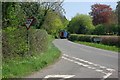
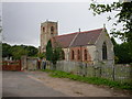
Bubbenhall - The Church of St Giles
This church dates back to the 13th and 14th centuries. It was substantially restored in 1860, with more changes being made in 1950s. Recently the extension visible on the left was added. Also, in 2000 the bells in the tower were overhauled and rehung. http://www.bubbenhall.info/church.html#building
Image: © David Stowell
Taken: 13 Jul 2005
0.14 miles
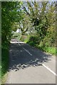
4
Start of a footpath
This footpath is used by the Warwickshire Centenary Way, and the Coventry Way.
Image: © Keith Williams
Taken: 31 Mar 2009
0.16 miles
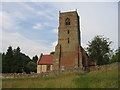
7
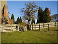
Lots of different angles
A footpath and gate next to Bubbenhall church.
The tree appears to be vertical whilst the church tower leans towards it.
Image: © Anthony Vosper
Taken: 27 Oct 2011
0.19 miles
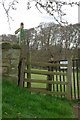
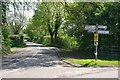
9
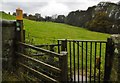
Bubbenhall, gate
Kissing gate at the western end of St. Giles' churchyard. The marker points to the route of Coventry Way and Shakespeare's Avon Way.
Image: © Mike Faherty
Taken: 15 Nov 2019
0.20 miles
