IMAGES TAKEN NEAR TO
Ashow Road, KENILWORTH, CV8 2UA
Introduction
This page details the photographs taken nearby to Ashow Road, CV8 2UA by members of the Geograph project.
The Geograph project started in 2005 with the aim of publishing, organising and preserving representative images for every square kilometre of Great Britain, Ireland and the Isle of Man.

There are currently over 7.5m images from over14,400 individuals and you can help contribute to the project by visiting https://www.geograph.org.uk
Image Map (Loading...)


Getting Data...Please wait
Leaflet Map data © OpenStreetMap
Images are licensed for reuse under creativecommons.org/licenses/by-sa/2.0
Notes
- Clicking on the map will re-center to the selected point.
- The higher the marker number, the further away the image location is from the centre of the postcode.
Image Listing (14 Images Found)
Images are licensed for reuse under creativecommons.org/licenses/by-sa/2.0
Image
Details
Distance
1
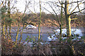
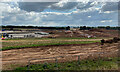
Concrete plant, Stoneleigh
What appears to be a concrete plant has been inserted into the Stoneleigh countryside between the A46 Kenilworth bypass and Kings Wood. It is presumably supplying materials to the A46 Stoneleigh Junction improvement scheme, work on which is underway nearby, though it is also on the edge of the route of the HS2 high speed railway, on which work has also started. The photo was taken from the A46.
Image: © A J Paxton
Taken: 16 Oct 2021
0.08 miles
2
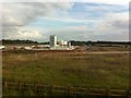
HS2 enabling works near Dalehouse Lane, April 2022 (8)
In the view southeast from Kingswood Farm the distant A46 dual carriageway can be seen (and heard). To the left is the concrete plant on the huge contractor's site east of the A46. A bridge will be built to carry the road over the railway Image
Image: © Robin Stott
Taken: 9 Apr 2022
0.10 miles
3
HS2 works, A46 crossing, September 2022
The view is from a Warwick-bound X18 bus on the A46. The extensive contractor's compound is serviced from the suite of portacabins, left. Note the notch in the distant skyline Image and the wide gap in the dark trees by the B4115, centre right: HS2 will run between them. The phone mast is thought to be on Stoneleigh Business Park. The fenced corridor, centre foreground, is the route of a gas pipeline. The mound on the right may be preparation for the realignment of the A46, which must cross the railway on an overbridge. At all the HS2 sites observed one is left in awe at the colossal procurement exercise that has been undertaken to secure the quantities of machines, materials and accommodation
Image: © Robin Stott
Taken: 15 Sep 2022
0.11 miles
5
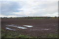
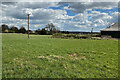
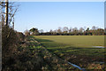
A wet field
Ploughed and ready for crops but too much water to bring on the machinery.
Image: © Malcolm Neal
Taken: 12 Nov 2017
0.17 miles
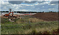
6

HS2 Construction Compound
Seen from the A46 Kenilworth bypass.
Image: © David Dixon
Taken: 1 Jun 2024
0.18 miles
7
HS2 works, A46 crossing, September 2022
The view is from a Warwick-bound X18 bus on the A46. Note the notch in the distant skyline Image and the wide gap in the dark trees by the B4115, right of centre: HS2 will run between them. Also right of centre a cutting is being formed to take the railway under the A46. The fenced area in the foreground is presumed to be reserved for the realignment of the A46, which must cross the railway on an overbridge. The distant phone mast is thought to be on Stoneleigh Business Park.
Image: © Robin Stott
Taken: 15 Sep 2022
0.20 miles
9
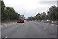
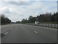
A46 near Stoneleigh
Continuing south west.
Image: © J.Hannan-Briggs
Taken: 13 Oct 2016
0.21 miles