IMAGES TAKEN NEAR TO
The Blundells, KENILWORTH, CV8 2PE
Introduction
This page details the photographs taken nearby to The Blundells, CV8 2PE by members of the Geograph project.
The Geograph project started in 2005 with the aim of publishing, organising and preserving representative images for every square kilometre of Great Britain, Ireland and the Isle of Man.

There are currently over 7.5m images from over14,400 individuals and you can help contribute to the project by visiting https://www.geograph.org.uk
Image Map (Loading...)


Getting Data...Please wait
Leaflet Map data © OpenStreetMap
Images are licensed for reuse under creativecommons.org/licenses/by-sa/2.0
Notes
- Clicking on the map will re-center to the selected point.
- The higher the marker number, the further away the image location is from the centre of the postcode.
Image Listing (195 Images Found)
Images are licensed for reuse under creativecommons.org/licenses/by-sa/2.0
Image
Details
Distance
1
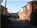
Clement House, The Blundells, Kenilworth
These flats were built c2006. Albion Street can be seen in the background.
The road leads to St Nicholas School and is a public highway up to the point where the photographer is standing, then continues as a public footpath through the school car park.
The low stone wall in the left foreground seems to have been made with reused worked sandstone blocks -possibly salvaged many years ago from the ruins of Kenilworth Abbey.
Image: © John Brightley
Taken: 16 Apr 2010
0.01 miles
2
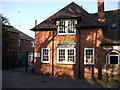
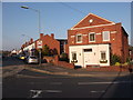
The Spring Playgroup, The Blundells, Kenilworth
The playgroup occupies a part of St Nicholas school buildings.
Image: © John Brightley
Taken: 16 Apr 2010
0.02 miles
3
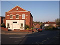
Spring Lane, Kenilworth
At the junction with Albion Street, looking towards Henry Street.
Image: © John Brightley
Taken: 16 Apr 2010
0.02 miles
4
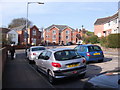
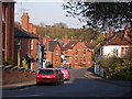
Spring Lane & Albion Street junction, Kenilworth.
The modern flats were built c. 2006 and stand at either side of The Blundells, a very old established public footpath which leads to St Nicholas school and on to the town centre.
Image: © John Brightley
Taken: 10 Apr 2010
0.02 miles
5
Spring Lane, Kenilworth
Seen from the junction with Albion Street. The trees in the background lie along the railway cutting to the rear of Arthur Street.
Image: © John Brightley
Taken: 16 Apr 2010
0.03 miles
6
Old buildings at Sports & Social Club, Albion Street
I think these may have originally been part of a farm building complex.
The start of Upper Rosemary Hill can be seen in the distance.
Image: © John Brightley
Taken: 10 Apr 2010
0.04 miles
7
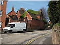
Spring Lane and Albion Street, Kenilworth
Albion Street to the left. The Old Church House, which was formerly a Baptist Church, stands on the corner. See http://www.theoldchurchhouse.co.uk/
Image: © John Brightley
Taken: 16 Apr 2010
0.04 miles
8
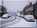
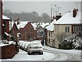
A snow-covered Albion Street, Kenilworth
Image: © John Brightley
Taken: 18 Dec 2010
0.04 miles
10
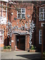
Metal sculpture, St Nicholas School, Kenilworth
A magnificent piece of metal sculpture at the entrance to the school.
It was created as a millennium project by the schoolchildren in association with sculptor Tim Tolkien.
http://homepage.ntlworld.com/jeremy.eastaugh/mill01.html
Image: © John Brightley
Taken: 17 Apr 2010
0.04 miles