IMAGES TAKEN NEAR TO
Oakfield, Inchbrook Road, KENILWORTH, CV8 2NE
Introduction
This page details the photographs taken nearby to Oakfield, Inchbrook Road, CV8 2NE by members of the Geograph project.
The Geograph project started in 2005 with the aim of publishing, organising and preserving representative images for every square kilometre of Great Britain, Ireland and the Isle of Man.

There are currently over 7.5m images from over14,400 individuals and you can help contribute to the project by visiting https://www.geograph.org.uk
Image Map (Loading...)


Getting Data...Please wait
Leaflet Map data © OpenStreetMap
Images are licensed for reuse under creativecommons.org/licenses/by-sa/2.0
Notes
- Clicking on the map will re-center to the selected point.
- The higher the marker number, the further away the image location is from the centre of the postcode.
Image Listing (14 Images Found)
Images are licensed for reuse under creativecommons.org/licenses/by-sa/2.0
Image
Details
Distance
1
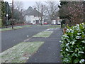
Snowing in Highland Road Kenilworth
This was a quick photo during a brief shower on March 06.
Image: © james dunlop
Taken: 2 Mar 2006
0.06 miles
2
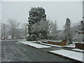
Highland Road Kenilworth Mar 06
A sudden snow flurry.
Image: © james dunlop
Taken: 2 Mar 2006
0.07 miles
3
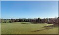
Northeast edge of Kenilworth
Properties in Highland Road look out over farmland in the valley of the Canley Brook. The view is from a Coventry-Leamington Spa train.
Image: © Robin Stott
Taken: 25 Nov 2021
0.09 miles
4
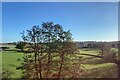
Canley Brook at Crackley
Obscured by trees, the brook heads southeast to join the Finham Brook by Dalehouse Lane Image Millburn Grange farm is on the left Image The view is from a Coventry-Leamington Spa train about to cross Millburn Viaduct to the right Image
Image: © Robin Stott
Taken: 25 Nov 2021
0.16 miles
5
Best Drive
Looking west along best Drive from its junction with Garlick Drive which are both just off Dalehouse lane.
Image: © Nigel Mykura
Taken: 29 Apr 2011
0.18 miles
6
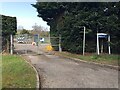
Sewage Works, Dalehouse Lane, Kenilworth
The site is not directly affected by HS2 but only 150 metres or so to the east is the confluence of the Canley and the Finham Brooks. Immediately to its northeast HS2 plans show a large 'land drainage area', in other words it's expected to flood. It will be interesting to see how that works out.
Image: © Robin Stott
Taken: 30 Mar 2021
0.20 miles
7
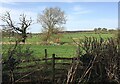
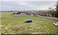
HS2 enabling works, Dalehouse Lane, Kenilworth (1)
Somewhere on the left is the confluence of the Canley and the Finham Brooks. Plans for HS2 show an area immediately to the north denoted as land drainage. In other words it's expected to flood and it would be better flooding here than the sites where HS2 crosses those brooks. The gentlemen in orange hi-vis may be using a machine to drive in posts to allow the area to be fenced off. Grassland in the foreground is within a camping and caravanning site, shown on Google Maps as The Meadow Farm.
Image: © Robin Stott
Taken: 30 Mar 2021
0.20 miles
9
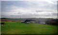
Millburn Grange, Crackley
HS2 will pass very close to this farm, on the left in this view from a Leamington Spa-Coventry train. The timber fence looks like recent HS2 provision, as may be guessed from Image taken in 2012.
Image: © Robin Stott
Taken: 8 Nov 2021
0.21 miles
10
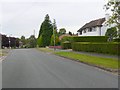
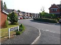
Highland Rd Kenilworth
Highland Rd is a cul de sac residential road on the north side of kenilworth just to the east of the kenilworth to Coventry railway line.
Image: © Nigel Mykura
Taken: 18 Jul 2010
0.21 miles