IMAGES TAKEN NEAR TO
Churchill Avenue, KENILWORTH, CV8 2ND
Introduction
This page details the photographs taken nearby to Churchill Avenue, CV8 2ND by members of the Geograph project.
The Geograph project started in 2005 with the aim of publishing, organising and preserving representative images for every square kilometre of Great Britain, Ireland and the Isle of Man.

There are currently over 7.5m images from over14,400 individuals and you can help contribute to the project by visiting https://www.geograph.org.uk
Image Map (Loading...)


Getting Data...Please wait
Leaflet Map data © OpenStreetMap
Images are licensed for reuse under creativecommons.org/licenses/by-sa/2.0
Notes
- Clicking on the map will re-center to the selected point.
- The higher the marker number, the further away the image location is from the centre of the postcode.
Image Listing (84 Images Found)
Images are licensed for reuse under creativecommons.org/licenses/by-sa/2.0
Image
Details
Distance
1
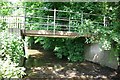
Making a deck, The Engine public house, Mill End, Kenilworth
In the later phase of the pandemic, pubs that had had to close invested in creating outdoor space so that they could safely serve socially-distanced patrons.
Image: © Robin Stott
Taken: 30 Mar 2021
0.04 miles
2
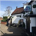
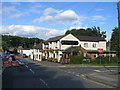
Kenilworth, The Cottage Inn
Suburban pub offering accommodation, at the corner of Stoneleigh Road and Stoneleigh Avenue. Internally, a single L-shaped bar for eating and drinking, with separate dining area at the back. Cask ales on offer at my visit: Courage Directors, Thwaites Lancaster Bomber, Wells Eagle & Bombardier. For some customer comments, see http://www.beerintheevening.com/pubs/s/33/33619/Cottage_Inn/Kenilworth http://www.tripadvisor.co.uk/Hotel_Review-g186398-d1533121-Reviews-The_Cottage_Inn-Kenilworth_Warwickshire_England.html
Image: © Mike Faherty
Taken: 16 Feb 2013
0.06 miles
3
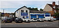
Just Tyres, Mill End
Just Tyres is situated on the corner of Mill End and Forge Road,
Image: © Paul Collins
Taken: 10 Sep 2023
0.06 miles
4
Mill End, Kenilworth
Looking towards Dalehouse Lane under the bridge that carries the Leamington - Coventry Line. The modern houses on the left (Woodmill Meadow) have recently been built on the site of the former Stickley's Works which had its own sidings from the railway above.
Image: © David Stowell
Taken: 27 Aug 2005
0.07 miles
5
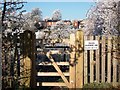
Entrance to allotments, The Close
Houses in Lower Ladyes Hills can be seen in the background.
Image: © John Brightley
Taken: 7 Dec 2010
0.07 miles
6
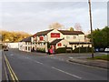
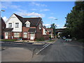
Stoneleigh Road, Kenilworth, looking towards Mill End
With the Cottage Inn on the right. The road through here has been closed for several months to allow for extra drainage to be installed as part of local flood relief measures.
Image: © David Stowell
Taken: 27 Aug 2005
0.08 miles
7
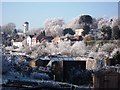
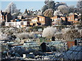
Frost at Odibourne allotments
The row of houses in the middle of the photo is the road known as Lower Ladyes Hills.
Tainters Hill converted water tower can be seen in the distance.
Image: © John Brightley
Taken: 7 Dec 2010
0.10 miles
8
Frosty scene, Odibourne allotments and Lower Ladyes Hills
Image: © John Brightley
Taken: 7 Dec 2010
0.10 miles
9
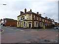
Kenilworth, Wyandotte Inn
Victorian corner pub on Stoneleigh Road, at the corner of Park Road. Internally, two entrances labelled "bar" and "lounge", now one space, but on different levels; games machines, TV, pool, darts. Cask ales on offer at my visit: Marston Bitter, Wychwood Hobgoblin. For some customer comments, see http://www.beerintheevening.com/pubs/s/33/33618/Wyandotte_Inn/Kenilworth Apparently named after a Native American tribe, though why transferred to Kenilworth is unclear: http://en.wikipedia.org/wiki/Wyandotte,_Michigan To explain this anomaly, see http://victorian.reuna.co.uk/index.php/the-engine-the-wyandotte-and-four-boddingtons
Image: © Mike Faherty
Taken: 16 Feb 2013
0.11 miles