IMAGES TAKEN NEAR TO
Whateleys Drive, KENILWORTH, CV8 2LU
Introduction
This page details the photographs taken nearby to Whateleys Drive, CV8 2LU by members of the Geograph project.
The Geograph project started in 2005 with the aim of publishing, organising and preserving representative images for every square kilometre of Great Britain, Ireland and the Isle of Man.

There are currently over 7.5m images from over14,400 individuals and you can help contribute to the project by visiting https://www.geograph.org.uk
Image Map (Loading...)


Getting Data...Please wait
Leaflet Map data © OpenStreetMap
Images are licensed for reuse under creativecommons.org/licenses/by-sa/2.0
Notes
- Clicking on the map will re-center to the selected point.
- The higher the marker number, the further away the image location is from the centre of the postcode.
Image Listing (185 Images Found)
Images are licensed for reuse under creativecommons.org/licenses/by-sa/2.0
Image
Details
Distance
1
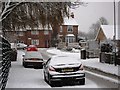
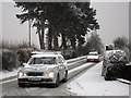
Whateleys Drive in the snow
The houses in the background are in Spring Lane.
Image: © John Brightley
Taken: 18 Dec 2010
0.01 miles
2
Spring Lane looking towards Whateleys Drive
Taken from near the railway bridge. The bungalows of Offa Drive are behind the hedgerow. Allotments off picture to the right. St Nicholas school in the background.
Image: © John Brightley
Taken: 10 Apr 2010
0.02 miles
3
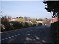
Spring Lane, Kenilworth
The junction with Whateleys Drive is on the right. The road is raised up above the surrounding ground on an embankment presumably built when the railway was constructed. It crosses the railway and becomes Whitemoor Road on the brow of the hill in the distance.
Image: © John Brightley
Taken: 14 Apr 2010
0.02 miles
4
Spring Lane, Kenilworth
A view from the junction with Whateleys Drive towards Arthur Street.
Image: © John Brightley
Taken: 10 Apr 2010
0.02 miles
5
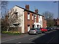
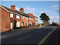
Spring Lane, Kenilworth
These appear to be the oldest properties in Spring Lane, and could have originally been part of the tannery that used to stand on or close to this spot. Do you know any more about their history?
Image: © John Brightley
Taken: 10 Apr 2010
0.02 miles
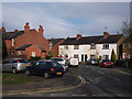
6
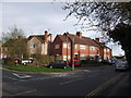
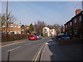
Spring Lane, Kenilworth
At the junction of Arthur Street, although all the properties in this view have Spring Lane addresses.
An old photo of this view, probably taken in the 1950's,can be found in 'Kenilworth in Camera volume II' (Graham Gould & John Drew,Baron Books,2008).
It shows that the grey rendered house was Smith's fish and chip shop and notes that during World War II there was an air raid shelter at the front where there were said to be springs and where the trees are now.
Image: © John Brightley
Taken: 11 Apr 2010
0.02 miles
9
Arthur Street seen from Spring Lane, Kenilworth
The white-painted terrace is 2-8 Arthur Street. The house on the far right is 43 Spring Lane. The property on the left is 1 Arthur St.
Image: © John Brightley
Taken: 11 Apr 2010
0.05 miles
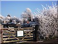
10
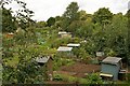
Autumn allotments
Allotments in central Kenilworth.
Image: © Colin Craig
Taken: 4 Sep 2009
0.05 miles