IMAGES TAKEN NEAR TO
Field Close, KENILWORTH, CV8 2JN
Introduction
This page details the photographs taken nearby to Field Close, CV8 2JN by members of the Geograph project.
The Geograph project started in 2005 with the aim of publishing, organising and preserving representative images for every square kilometre of Great Britain, Ireland and the Isle of Man.

There are currently over 7.5m images from over14,400 individuals and you can help contribute to the project by visiting https://www.geograph.org.uk
Image Map
Images are licensed for reuse under creativecommons.org/licenses/by-sa/2.0
Notes
- Clicking on the map will re-center to the selected point.
- The higher the marker number, the further away the image location is from the centre of the postcode.
Image Listing (31 Images Found)
Images are licensed for reuse under creativecommons.org/licenses/by-sa/2.0
Image
Details
Distance
1

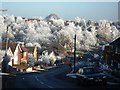
Frost-covered telephone wires, Villiers Road
Image: © John Brightley
Taken: 7 Dec 2010
0.05 miles
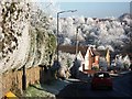
2
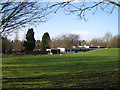
Frost on Knowle Hill
Frost covered trees in Knowle Hill nature reserve, seen from Villiers Road.
Image: © John Brightley
Taken: 7 Dec 2010
0.05 miles
3
Frost covered hedgerow in Villiers Road
Image: © John Brightley
Taken: 7 Dec 2010
0.07 miles
4
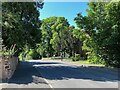
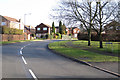
Top of Villiers Road, Kenilworth
At its junction with Park Hill.
Image: © Robin Stott
Taken: 27 May 2022
0.10 miles
5

Frost-covered trees, Knowle Hill nature reserve
A view looking towards the trees of Kenilworth Common in the far distance.
In the middle distance the rear of houses in Finham Road can just be seen.
Image: © John Brightley
Taken: 7 Dec 2010
0.11 miles
8
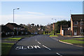
Top of Rawnsley Drive, Kenilworth
The junction ahead is with Thirlestane Close.
Image: © Robin Stott
Taken: 17 Jan 2010
0.15 miles
9
Rawnsley Drive, Kenilworth
Named after a long-serving local councillor. On the right is Framlingham Grove.
Image: © Robin Stott
Taken: 17 Jan 2010
0.15 miles
10
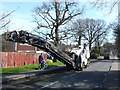
Road Surface Stripper
This machine is parked in Leyes Lane a few metres from its junction with Windy Arbor. Part of the surface had already been removed and more was about to be scraped off.
Image: © Nigel Mykura
Taken: 25 Mar 2012
0.15 miles