IMAGES TAKEN NEAR TO
The Deer Leap, KENILWORTH, CV8 2HQ
Introduction
This page details the photographs taken nearby to The Deer Leap, CV8 2HQ by members of the Geograph project.
The Geograph project started in 2005 with the aim of publishing, organising and preserving representative images for every square kilometre of Great Britain, Ireland and the Isle of Man.

There are currently over 7.5m images from over14,400 individuals and you can help contribute to the project by visiting https://www.geograph.org.uk
Image Map (Loading...)


Getting Data...Please wait
Leaflet Map data © OpenStreetMap
Images are licensed for reuse under creativecommons.org/licenses/by-sa/2.0
Notes
- Clicking on the map will re-center to the selected point.
- The higher the marker number, the further away the image location is from the centre of the postcode.
Image Listing (47 Images Found)
Images are licensed for reuse under creativecommons.org/licenses/by-sa/2.0
Image
Details
Distance
2
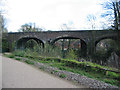
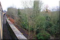
Railway viaduct, Kenilworth Common
The viaduct carrying the Coventry to Leamington railway line over the Finham Brook, viewed from the Kenilworth Greenway.
Image: © E Gammie
Taken: 16 Apr 2012
0.03 miles
3
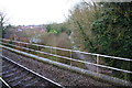
Railway crosses stream at Kenilworth Junction
Image: © Roger Templeman
Taken: 4 Mar 2017
0.03 miles
4
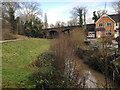
Finham Brook between the Common and Woodville Meadow, Kenilworth
The footpath continues by the railway, left. The handsome viaduct carries the Coventry-Leamington line over the brook. Note the flood gauge, lower right.
Image: © Robin Stott
Taken: 22 Jan 2021
0.05 miles
5
Charter train waits at Kenilworth for Cross Country service to pass
Image: © Roger Templeman
Taken: 4 Mar 2017
0.05 miles
6
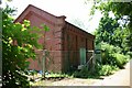
Severn Trent Water pumping station at Mill End
Image: © Keith Williams
Taken: 8 Jun 2008
0.08 miles
7
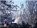
Frost in Woodmill Meadow
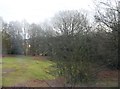
The large trees in the background are on Kenilworth Common.
Image: © John Brightley
Taken: 7 Dec 2010
0.10 miles
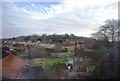
8
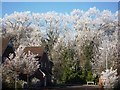
A frosty view from Knowle Hill nature reserve
A view towards Tainters Hill converted water tower which can be seen in the distance in the centre of the photo.
The houses in the foreground are in Broomybank, those slightly further away are in Watling Road.
Image: © John Brightley
Taken: 7 Dec 2010
0.11 miles
10
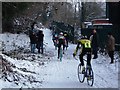
Kenilworth Common Cyclocross 2010
Looking from the Forge Road entrance past the old water works on the right towards the railway viaduct.
Image: © John Brightley
Taken: 26 Dec 2010
0.11 miles