IMAGES TAKEN NEAR TO
The Close, KENILWORTH, CV8 2HN
Introduction
This page details the photographs taken nearby to The Close, CV8 2HN by members of the Geograph project.
The Geograph project started in 2005 with the aim of publishing, organising and preserving representative images for every square kilometre of Great Britain, Ireland and the Isle of Man.

There are currently over 7.5m images from over14,400 individuals and you can help contribute to the project by visiting https://www.geograph.org.uk
Image Map (Loading...)


Getting Data...Please wait
Leaflet Map data © OpenStreetMap
Images are licensed for reuse under creativecommons.org/licenses/by-sa/2.0
Notes
- Clicking on the map will re-center to the selected point.
- The higher the marker number, the further away the image location is from the centre of the postcode.
Image Listing (98 Images Found)
Images are licensed for reuse under creativecommons.org/licenses/by-sa/2.0
Image
Details
Distance
1
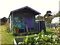
'My Shed, My Rules'
The sheds of the Odibourne Allotments, Kenilworth, are the subject of their own book, 'Odibourne Sheds: rural retreats in a Kenilworth allotment', by Peter James, published by the Bothy Press in 2020.
Image: © A J Paxton
Taken: 18 Sep 2021
0.04 miles
2
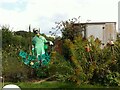
I'm in the Green Zone
A scarecrow, probably more decorative than functional, at the Odibourne allotments in Kenilworth, which were open to the public for the Heritage Open Days 2021.
Image: © A J Paxton
Taken: 18 Sep 2021
0.04 miles
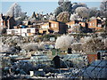
3
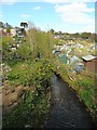
Frost at Odibourne allotments
The row of houses in the middle of the photo is the road known as Lower Ladyes Hills.
Tainters Hill converted water tower can be seen in the distance.
Image: © John Brightley
Taken: 7 Dec 2010
0.04 miles
4
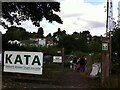
Odibourne Allotments, Manor Road, Kenilworth
The allotments were open to the public for the Heritage Open Days 2021 and Edible England events; members of the Kenilworth Allotment Tenants' Association (KATA) can be seen welcoming visitors.
The Odibourne site was established in 1919, when Kenilworth Urban District Council bought land from the estate of the deceased William Thomas Pears. The council had recently decided to build on the 'Noah's Ark' allotments nearby, but was obliged under the 1908 Smallholding & Allotments Act to provide sufficient land for local people who wanted plots for growing food. The site is owned today by Kenilworth Town Council, but has been managed since 1983 by KATA (information taken from a notice board on the site).
Image: © A J Paxton
Taken: 18 Sep 2021
0.04 miles
5
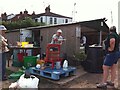
Apple Pressing at Odibourne Allotments, Kenilworth
The allotment site was open to the public as part of the Heritage Open Days 2021 and Edible England events.
Image: © A J Paxton
Taken: 18 Sep 2021
0.05 miles
6
Stoneleigh Road, Kenilworth, looking towards Mill End
With the Cottage Inn on the right. The road through here has been closed for several months to allow for extra drainage to be installed as part of local flood relief measures.
Image: © David Stowell
Taken: 27 Aug 2005
0.05 miles
7
Plot 58a, Odibourne Allotments, Kenilworth
These allotments, which to this city dweller appear impossibly idyllic, were open to the public for the Heritage Open Days 2021. Behind the idyll, of course, lies hard work and long term commitment, the challenge of group politics, the uncertainty of the weather and the threat, even here, of theft and vandalism. The Odibourne allotments were established in 1919.
Image: © A J Paxton
Taken: 18 Sep 2021
0.06 miles
8

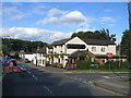
The Wyandotte Inn, Kenilworth
This pub on the corner of Stoneleigh Road and Park Road is notable for its unusual name. According to a notice in the pub (which should be taken with a pinch of salt) some members of the Wyandotte tribe, having been driven out of their native land in Ohio, moved to England and settled in Kenilworth in the 19th century. The landlord of the pub was so impressed by this that he decided to rename it in their honour, in return for which each landlord becomes an honorary chief. However, John Brightley tells a more plausible story here: Image Whatever the truth, this is a pleasant place in the back streets of the town and well worth seeking out.
Image: © Stephen McKay
Taken: 23 Sep 2012
0.06 miles
9
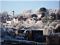
Frosty scene, Odibourne allotments and Lower Ladyes Hills
Image: © John Brightley
Taken: 7 Dec 2010
0.06 miles